1900s (20th Century) Maps of Nethers, Virginia
Explore 8 historic maps of Nethers from the 1900s (20th Century). These maps offer a rare glimpse into what life looked like during the 1900s — showing old roads, neighborhoods, homes, and landmarks that have changed or disappeared over time.
Whether you're researching your family's past, planning a metal detecting trip, or studying how Nethers's landscape evolved across the 1900s, these high-resolution maps are a powerful tool for exploring the history of this region.
- Focus on a specific era: All maps on this page are from the 1900s, giving you a focused view of this time period.
- See what’s changed: Compare century-old streets, trails, and buildings to today's modern landscape using overlays and satellite layers.
- Research with precision: Use these maps for genealogy, historical research, land use analysis, or educational projects.
- View, download, or print: Maps are fully viewable online in high resolution, and can be downloaded or printed for your own records.
Start exploring Nethers's history through authentic maps from the 1900s. This is your window into the past.
Nethers, VA maps
(8)- 1905 Map of Luray, 1910 Print
 1905 Luray1910 Print · USGSThe Blue Ridge and Shenandoah Valley are frozen in time just after the turn of the century, showing the critical rail networks and mountain gaps of the period. Genealogists can trace family names and settlements like Luray, Front Royal, and Strasburg along the Shenandoah Valley Railroad.4 unique versions available
 - 1929 Map of Stony Man
 1929 Stony Man1929 Print · USGSBlue Ridge mountain life and the early development of Shenandoah National Park are captured here just as the park boundary was being established. Genealogists and hikers can trace old mountain routes to the President Hoover Community Sch, locate St Luke Episcopal Mission, or find early trail markers at Sexton Shelter.2 unique versions available
 - 1933 Map of Stony Man
 1933 Stony Man1933 Print · USGSThe Blue Ridge highlands and Page Valley are captured here during the early years of the national park era. Genealogists and historians can trace family locations through mountain hollows and riverside crossings like Stricklers Ferry, St George Mission, and Baileys Store.3 unique versions available
 - 1949 Map of Charlottesville
 1949 Charlottesville1949 Print · USGSThe Shenandoah Valley and Blue Ridge appear in the late 1940s as a thriving corridor of rail and river commerce. Researchers can trace the mid-century footprints of Harrisonburg, Staunton, and Culpeper alongside the historic routes of the Southern Railway.2 unique versions available
 - 1956 Map of Charlottesville, 1966 Print
 1956 Charlottesville1966 Print · USGSThe Shenandoah Valley and Blue Ridge are captured in detail during the mid-1960s as the modern interstate system began to emerge. Genealogists and historians can trace rail-connected hubs like Waynesboro or follow the river paths of the Rapidan River and Rivanna River.4 unique versions available
 - 1965 Map of Old Rag Mtn, 1966 Print
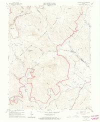 1965 Old Rag Mtn1966 Print · USGSShenandoah National Park and the eastern Blue Ridge foothills come to life in the mid-1960s. Researchers can locate the historic Corbin Cabin, trace the original route of the APPALACHIAN TRAIL, and explore the rural road networks of Etlan and Nethers.6 unique versions available
 - 1986 Map of Front Royal
 1986 Front Royal1986 Print · USGSThe northern Shenandoah Valley and the Blue Ridge crest are captured here in the mid-eighties as modern highways began to bypass historic valley towns. Researchers can trace ancestral connections near Peola Mills, navigate the gaps like Manassas Gap, or study the river bends around Luray.3 unique versions available
 - 1994 Map of Old Rag Mountain, 1997 Print
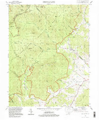 1994 Old Rag Mountain1997 Print · USGSThe Madison County highlands are captured here in the mid-1990s, where high wilderness peaks meet rural valley life. Genealogists and hikers can trace historical sites like Corbin Cabin, the Bethlehem Ch, and the rugged course of the Hughes River.
End of results
Showing maps 1-8 of 8
Top cities near Nethers
- Luray historical maps
- Stanley historical maps
- Brightwood historical maps
- Flint Hill historical maps
- Sperryville historical maps
- Madison historical maps
See more
Frequently asked questions
- What are the different types of historical maps available for Nethers?
- What is the oldest map of Nethers?
- Where can I purchase historical maps of Nethers for my home or office?
- Where can I download high-res historical maps of Nethers?
- Are there historical topographic maps available for Nethers?
- Is there historical aerial imagery available for Nethers?
- Where are historical maps of Nethers sourced from?