1900s (20th Century) Maps of Brush Harbor, Virginia
Explore 7 historic maps of Brush Harbor from the 1900s (20th Century). These maps offer a rare glimpse into what life looked like during the 1900s — showing old roads, neighborhoods, homes, and landmarks that have changed or disappeared over time.
Whether you're researching your family's past, planning a metal detecting trip, or studying how Brush Harbor's landscape evolved across the 1900s, these high-resolution maps are a powerful tool for exploring the history of this region.
- Focus on a specific era: All maps on this page are from the 1900s, giving you a focused view of this time period.
- See what’s changed: Compare century-old streets, trails, and buildings to today's modern landscape using overlays and satellite layers.
- Research with precision: Use these maps for genealogy, historical research, land use analysis, or educational projects.
- View, download, or print: Maps are fully viewable online in high resolution, and can be downloaded or printed for your own records.
Start exploring Brush Harbor's history through authentic maps from the 1900s. This is your window into the past.
Brush Harbor, VA maps
(7)- 1932 Map of Blacksburg
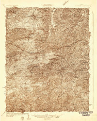 1932 Blacksburg1932 Print · USGSMontgomery and Floyd Counties are documented here in the early thirties as the regional rail and coal economy thrived. Genealogists can trace family homesteads near landmarks like the Virginia Polytechnic Institute, Merrimac Mines, and Christiansburg Industrial Sch.2 unique versions available
 - 1937 Map of Blacksburg
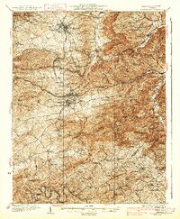 1937 Blacksburg1937 Print · USGSMontgomery County was a hub of higher education, coal mining, and rail transport in the 1930s. Researchers can trace the early grounds of the Virginia Polytechnic Institute and locate numerous rural landmarks like Merrimac Mines, Kanodee Mill, and Yellow Sulphur Springs.3 unique versions available
 - 1955 Map of Bluefield
 1955 Bluefield1955 Print · USGSThe Central Appalachian borderlands come alive in the mid-fifties, showing the coal and rail networks connecting Bluefield to Beckley. Researchers can trace the industrial landscape of the New River Ordnance Plant and the terrain of Burkes Garden.
 - 1957 Map of Bluefield, 1967 Print
 1957 Bluefield1967 Print · USGSThe heart of Central Appalachia in the mid-fifties is defined by the winding rail lines and river valleys of the coalfields. Researchers can trace the industrial footprints of towns like Welch and Princeton or locate landmarks such as the Bluestone Reservoir and Claytor Lake.2 unique versions available
 - 1961 Map of Bluefield
 1961 Bluefield1961 Print · USGSThe coalfields and mountain ridges of southern West Virginia and southwest Virginia are captured in the early sixties. Genealogists can trace family ties through rail-linked towns like Princeton and Richlands or along the shores of Bluestone Reservoir.
 - 1965 Map of Ironto, 1968 Print
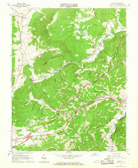 1965 Ironto1968 Print · USGSIn the mid-1960s, the railroad and river valleys of Montgomery County show a landscape of growing infrastructure and deep-rooted rural identity. Researchers can trace family sites and community centers from Alleghany Springs and Shawsville to rural landmarks like Den Hill Church and Lusters Gate.5 unique versions available
 - 1982 Map of Radford, 1983 Print
 1982 Radford1983 Print · USGSThe New River Valley and surrounding highlands are shown during a period of significant regional growth in the early eighties. Genealogists and historians can trace the development of VPI, locate historic sites like Yellow Sulphur Springs, and follow the Norfolk and Western rail lines through the gaps.2 unique versions available
End of results
Showing maps 1-7 of 7
Top cities near Brush Harbor
- Blacksburg historical maps
- Christiansburg historical maps
- Merrimac historical maps
- Plum Creek historical maps
- Prices Fork historical maps
- Belview historical maps
See more
Frequently asked questions
- What are the different types of historical maps available for Brush Harbor?
- What is the oldest map of Brush Harbor?
- Where can I purchase historical maps of Brush Harbor for my home or office?
- Where can I download high-res historical maps of Brush Harbor?
- Are there historical topographic maps available for Brush Harbor?
- Is there historical aerial imagery available for Brush Harbor?
- Where are historical maps of Brush Harbor sourced from?