1960s Maps of Norfolk, Virginia
Explore 4 historic maps of Norfolk from the 1960s. These maps offer a rare glimpse into what life looked like during the 1960s — showing old roads, neighborhoods, homes, and landmarks that have changed or disappeared over time.
Whether you're researching your family's past, planning a metal detecting trip, or studying how Norfolk's landscape evolved across the 1960s, these high-resolution maps are a powerful tool for exploring the history of this region.
- Focus on a specific era: All maps on this page are from the 1960s, giving you a focused view of this time period.
- See what’s changed: Compare century-old streets, trails, and buildings to today's modern landscape using overlays and satellite layers.
- Research with precision: Use these maps for genealogy, historical research, land use analysis, or educational projects.
- View, download, or print: Maps are fully viewable online in high resolution, and can be downloaded or printed for your own records.
Start exploring Norfolk's history through authentic maps from the 1960s. This is your window into the past.
Norfolk, VA maps
(4)- 1964 Map of Little Creek, 1968 Print
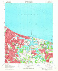 1964 Little Creek1968 Print · USGSVirginia's coastline during the mid-sixties reveals a period of intense military and suburban growth along the Chesapeake. Genealogists and historians can trace neighborhood development in Ocean View and locate military landmarks like the Little Creek Amphibious Base.5 unique versions available
 - 1965 Map of Norfolk North, 1968 Print
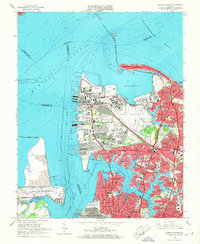 1965 Norfolk North1968 Print · USGSMid-century Norfolk is defined by its massive naval installations and the busy waterfront of the Elizabeth and Lafayette Rivers. Researchers can trace the layout of the Naval Base, find the Old Point Ferry landing, or locate family plots in Forest Lawn Cemetery.6 unique versions available
 - 1965 Map of Kempsville, 1968 Print
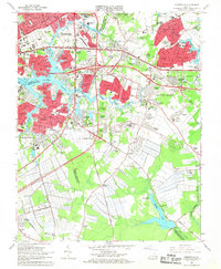 1965 Kempsville1968 Print · USGSCoastal Virginia during the mid-sixties transition shows the rapid growth of Virginia Beach and Norfolk over former farmland. Genealogists and historians can trace suburban development around Kempsville, locate ancestral sites like Jones Cem, or find rural landmarks such as Old St Matthews Ch.6 unique versions available
 - 1965 Map of Norfolk South, 1968 Print
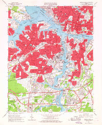 1965 Norfolk South1968 Print · USGSThe Tidewater region in the mid-sixties reveals a dense network of military installations and maritime industry along the Elizabeth River. Researchers can trace the layout of the U S Naval Shipyard, find the site of the former South Norfolk Airport, and locate established neighborhoods like Cavalier Manor.6 unique versions available
End of results
Showing maps 1-4 of 4
Top cities of Norfolk
Frequently asked questions
- What are the different types of historical maps available for Norfolk?
- What is the oldest map of Norfolk?
- Where can I purchase historical maps of Norfolk for my home or office?
- Where can I download high-res historical maps of Norfolk?
- Are there historical topographic maps available for Norfolk?
- Is there historical aerial imagery available for Norfolk?
- Where are historical maps of Norfolk sourced from?