1960s Maps of Cape Charles, Virginia
Explore 7 historic maps of Cape Charles from the 1960s. These maps offer a rare glimpse into what life looked like during the 1960s — showing old roads, neighborhoods, homes, and landmarks that have changed or disappeared over time.
Whether you're researching your family's past, planning a metal detecting trip, or studying how Cape Charles's landscape evolved across the 1960s, these high-resolution maps are a powerful tool for exploring the history of this region.
- Focus on a specific era: All maps on this page are from the 1960s, giving you a focused view of this time period.
- See what’s changed: Compare century-old streets, trails, and buildings to today's modern landscape using overlays and satellite layers.
- Research with precision: Use these maps for genealogy, historical research, land use analysis, or educational projects.
- View, download, or print: Maps are fully viewable online in high resolution, and can be downloaded or printed for your own records.
Start exploring Cape Charles's history through authentic maps from the 1960s. This is your window into the past.
Cape Charles, VA maps
(7)- 1961 Map of Eastville
 1961 Eastville1961 Print · USGSThe Eastern Shore and Outer Banks are captured here in the mid-twentieth century, showing a maritime landscape of lighthouses, rail-linked towns, and naval outposts. Researchers can trace the Pennsylvania Railroad through Parksley or locate historical sites like Chincoteague Field Naval Auxiliary Air Station and Tangier Island.
 - 1964 Map of Richmond
 1964 Richmond1964 Print · USGSCoastal and central Virginia are mapped during the mid-twentieth century, showing the critical intersection of rail, river, and military life. Genealogists can trace family roots through rural county seats like Amelia or find vanished coastal neighborhoods near Phoebus and Hilton Village.
 - 1966 Map of Eastville
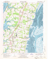
 1966 Eastville1966 Print · USGSThe Delmarva Peninsula and Outer Banks appear in the mid-sixties, showing a landscape of maritime trade, military outposts, and fishing villages. Researchers can trace the lines of the Norfolk & Southern through Exmore and Parksley or locate historical sites like Fort John Custis and the Janes Island Lighthouse.
 - 1968 Map of Cape Charles, 1970 Print
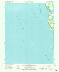
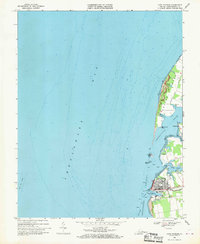 1968 Cape Charles1970 Print · USGSCape Charles was a thriving coastal rail hub in the late sixties, serving as a critical link between the Delmarva Peninsula and the bay. Researchers can trace the Penn Central tracks to Cape Charles Harbor or locate family sites near Savage Neck and Owens Landing.2 unique versions available
 - 1968 Map of Cheriton, 1971 Print
 1968 Cheriton1971 Print · USGSNorthampton County's eastern shore is documented here during the late sixties, showcasing the intersection of traditional neck-land farming and the maritime culture of the Chesapeake. Genealogists and historians can trace family locations near Eastville Station, Oyster, and the Bethlehem Temple Mission.3 unique versions available
 - 1968 Map of Elliotts Creek, 1971 Print
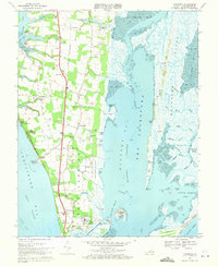
 1968 Elliotts Creek1971 Print · USGSThe Eastern Shore of Virginia in the late sixties reveals a coastal landscape of quiet settlements and historic estates along the bay. Genealogists and researchers can locate the Tomb of Custis near Arlington or trace tidal waterways like Old Plantation Creek.4 unique versions available
 - 1968 Map of Townsend, 1971 Print
 1968 Townsend1971 Print · USGSCoastal Northampton County at the end of the sixties shows a transition from agricultural life to military and maritime operations. Genealogists can trace family names at Hunts Wharf and Cheapside, or locate the Cape Charles Air Force Sta near the rail terminus.6 unique versions available
End of results
Showing maps 1-7 of 7
Top cities near Cape Charles
- Nassawadox historical maps
- Cheriton historical maps
- Eastville historical maps
- Franktown historical maps
Frequently asked questions
- What are the different types of historical maps available for Cape Charles?
- What is the oldest map of Cape Charles?
- Where can I purchase historical maps of Cape Charles for my home or office?
- Where can I download high-res historical maps of Cape Charles?
- Are there historical topographic maps available for Cape Charles?
- Is there historical aerial imagery available for Cape Charles?
- Where are historical maps of Cape Charles sourced from?