1970s Maps of Cape Charles, Virginia
Explore 5 historic maps of Cape Charles from the 1970s. These maps offer a rare glimpse into what life looked like during the 1970s — showing old roads, neighborhoods, homes, and landmarks that have changed or disappeared over time.
Whether you're researching your family's past, planning a metal detecting trip, or studying how Cape Charles's landscape evolved across the 1970s, these high-resolution maps are a powerful tool for exploring the history of this region.
- Focus on a specific era: All maps on this page are from the 1970s, giving you a focused view of this time period.
- See what’s changed: Compare century-old streets, trails, and buildings to today's modern landscape using overlays and satellite layers.
- Research with precision: Use these maps for genealogy, historical research, land use analysis, or educational projects.
- View, download, or print: Maps are fully viewable online in high resolution, and can be downloaded or printed for your own records.
Start exploring Cape Charles's history through authentic maps from the 1970s. This is your window into the past.
Cape Charles, VA maps
(5)- 1973 Map of Richmond, 1974 Print
 1973 Richmond1974 Print · USGSThe Virginia Tidewater and Piedmont come alive in the early seventies, showcasing a region defined by its great rivers and massive military installations. Researchers can trace the mid-century growth of Richmond or locate family sites near Amelia Court House and Highland Springs.2 unique versions available
 - 1977 Map of Townsend, 1982 Print
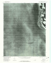
 1977 Townsend1982 Print · USGSThe tip of the Delmarva Peninsula is seen here in the late seventies, showing the rural character of the Virginia Eastern Shore. Researchers can trace the layout of coastal settlements like Townsend and Kiptopeke against the marshes of Magothy Bay.
 - 1977 Map of Elliotts Creek, 1982 Print
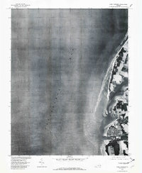
 1977 Elliotts Creek1982 Print · USGSThe Eastern Shore of Virginia's Atlantic-facing coastline is captured here in the late seventies just as the winter season began. Researchers can trace the coastal landscape around Arlington and the winding paths of Elliotts Creek and Old Plantation Cr.
 - 1977 Map of Cape Charles, 1982 Print
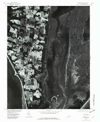
 1977 Cape Charles1982 Print · USGSCape Charles and the Eastern Shore of Virginia are captured in this 1970s aerial survey just as the coastal landscape was being documented for soil conservation. Genealogists and local historians can trace the streets of Cape Charles and the shoreline of Cherrystone Inlet.
 - 1977 Map of Cheriton, 1982 Print
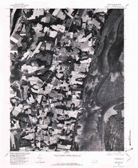 1977 Cheriton1982 Print · USGSThe Eastern Shore of Virginia comes into focus in the late seventies, showing the traditional agricultural and maritime patterns of the peninsula. Researchers can trace land use around Eastville and locate coastal hamlets like Oyster and Old Plantation.
End of results
Showing maps 1-5 of 5
Top cities near Cape Charles
- Nassawadox historical maps
- Cheriton historical maps
- Eastville historical maps
- Franktown historical maps
Frequently asked questions
- What are the different types of historical maps available for Cape Charles?
- What is the oldest map of Cape Charles?
- Where can I purchase historical maps of Cape Charles for my home or office?
- Where can I download high-res historical maps of Cape Charles?
- Are there historical topographic maps available for Cape Charles?
- Is there historical aerial imagery available for Cape Charles?
- Where are historical maps of Cape Charles sourced from?