1960s Maps of Chesapeake Beach, Virginia
Explore 2 historic maps of Chesapeake Beach from the 1960s. These maps offer a rare glimpse into what life looked like during the 1960s — showing old roads, neighborhoods, homes, and landmarks that have changed or disappeared over time.
Whether you're researching your family's past, planning a metal detecting trip, or studying how Chesapeake Beach's landscape evolved across the 1960s, these high-resolution maps are a powerful tool for exploring the history of this region.
- Focus on a specific era: All maps on this page are from the 1960s, giving you a focused view of this time period.
- See what’s changed: Compare century-old streets, trails, and buildings to today's modern landscape using overlays and satellite layers.
- Research with precision: Use these maps for genealogy, historical research, land use analysis, or educational projects.
- View, download, or print: Maps are fully viewable online in high resolution, and can be downloaded or printed for your own records.
Start exploring Chesapeake Beach's history through authentic maps from the 1960s. This is your window into the past.
Chesapeake Beach, VA maps
(2)- 1964 Map of Richmond
 1964 Richmond1964 Print · USGSCoastal and central Virginia are mapped during the mid-twentieth century, showing the critical intersection of rail, river, and military life. Genealogists can trace family roots through rural county seats like Amelia or find vanished coastal neighborhoods near Phoebus and Hilton Village.
 - 1968 Map of Reedville, 1971 Print
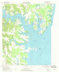 1968 Reedville1971 Print · USGSThe Northern Neck of Virginia is shown in the late sixties as a thriving coastal landscape defined by the menhaden fishing industry and maritime commerce. Trace family roots and local landmarks from Reedville to Rehoboth Church, or explore the shoreline near Dameron Marsh and Fleeton.4 unique versions available
End of results
Showing maps 1-2 of 2
Top cities near Chesapeake Beach
- Kilmarnock historical maps
- Irvington historical maps
- White Stone historical maps
- Weems historical maps
- Heathsville historical maps
- Lancaster historical maps
Frequently asked questions
- What are the different types of historical maps available for Chesapeake Beach?
- What is the oldest map of Chesapeake Beach?
- Where can I purchase historical maps of Chesapeake Beach for my home or office?
- Where can I download high-res historical maps of Chesapeake Beach?
- Are there historical topographic maps available for Chesapeake Beach?
- Is there historical aerial imagery available for Chesapeake Beach?
- Where are historical maps of Chesapeake Beach sourced from?