1940s Maps of Germans Corner, Virginia
Explore 3 historic maps of Germans Corner from the 1940s. These maps offer a rare glimpse into what life looked like during the 1940s — showing old roads, neighborhoods, homes, and landmarks that have changed or disappeared over time.
Whether you're researching your family's past, planning a metal detecting trip, or studying how Germans Corner's landscape evolved across the 1940s, these high-resolution maps are a powerful tool for exploring the history of this region.
- Focus on a specific era: All maps on this page are from the 1940s, giving you a focused view of this time period.
- See what’s changed: Compare century-old streets, trails, and buildings to today's modern landscape using overlays and satellite layers.
- Research with precision: Use these maps for genealogy, historical research, land use analysis, or educational projects.
- View, download, or print: Maps are fully viewable online in high resolution, and can be downloaded or printed for your own records.
Start exploring Germans Corner's history through authentic maps from the 1940s. This is your window into the past.
Germans Corner, VA maps
(3)- 1943 Map of Montross, 1961 Print
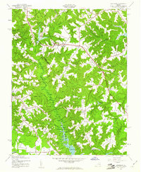 1943 Montross1961 Print · USGSMid-century Westmoreland and Richmond counties are captured here just as the road network was modernizing. Researchers can trace historic family landmarks and community hubs from Montross to Tallent Town, including St James Ch and Chandlers Millpond.
 - 1944 Map of Montross
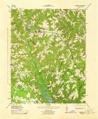 1944 Montross1944 Print · USGSThe Northern Neck of Virginia is captured here during the mid-forties, showing the rural crossroads of Westmoreland and Richmond Counties. Genealogists can trace family landmarks and community centers such as Tallent Town, Nomini Sch, and the Washington and Lee High School.
 - 1948 Map of Washington
 1948 Washington1948 Print · USGSThe Potomac and Chesapeake regions in the late 1940s reveal a landscape of expanding military reach and deep-rooted Tidewater settlements. Trace old rail corridors like the Richmond Fredericksburg & Potomac RR or locate landmarks like the Wakefield Washington Monument and St. Marys College.2 unique versions available
End of results
Showing maps 1-3 of 3
Top cities near Germans Corner
Frequently asked questions
- What are the different types of historical maps available for Germans Corner?
- What is the oldest map of Germans Corner?
- Where can I purchase historical maps of Germans Corner for my home or office?
- Where can I download high-res historical maps of Germans Corner?
- Are there historical topographic maps available for Germans Corner?
- Is there historical aerial imagery available for Germans Corner?
- Where are historical maps of Germans Corner sourced from?