1940s Maps of Richmond, Virginia
Explore 5 historic maps of Richmond from the 1940s. These maps offer a rare glimpse into what life looked like during the 1940s — showing old roads, neighborhoods, homes, and landmarks that have changed or disappeared over time.
Whether you're researching your family's past, planning a metal detecting trip, or studying how Richmond's landscape evolved across the 1940s, these high-resolution maps are a powerful tool for exploring the history of this region.
- Focus on a specific era: All maps on this page are from the 1940s, giving you a focused view of this time period.
- See what’s changed: Compare century-old streets, trails, and buildings to today's modern landscape using overlays and satellite layers.
- Research with precision: Use these maps for genealogy, historical research, land use analysis, or educational projects.
- View, download, or print: Maps are fully viewable online in high resolution, and can be downloaded or printed for your own records.
Start exploring Richmond's history through authentic maps from the 1940s. This is your window into the past.
Richmond, VA maps
(5)- 1942 Map of Westhampton
 1942 Westhampton1942 Print · USGSThe James River corridor west of Richmond was a mix of historic estates and rural crossroads in the early 1940s. Genealogists can locate family landmarks like Hammack Mill, trace the Kanawha Canal, or find old sites like the Bellona Arsenal (Ruins).2 unique versions available
 - 1943 Map of Chesterfield
 1943 Chesterfield1943 Print · USGSChesterfield County during the early 1940s shows a landscape of rural schoolhouses and country churches transitioning toward modern public spaces. Genealogists can trace family landmarks like Good Hope School, Ramsey Church, and the Shawondasee Boy Scout Camp.3 unique versions available
 - 1943 Map of Richmond, 1972 Print
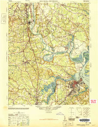
 1943 Richmond1972 Print · USGSCoastal Virginia and the state capital are shown in detail during the mid-century era of infrastructure expansion. Genealogists and historians can trace the grounds of Richmond Nat Battlefield Park, locate the Yorktown Nat Cem, or follow the many rural routes through Amelia Court House and Tappahannock.
 - 1946 Map of Bermuda Hundred
 1946 Bermuda Hundred1946 Print · USGSThe James River corridor south of Richmond is shown here just after the war, where industrial hubs like Hopewell meet colonial-era landscapes. Genealogists and historians can trace the foundations of Bermuda Hundred, the grounds of Camp Lee, and landmarks like Shirley or Drewrys Bluff.2 unique versions available
 - 1949 Map of Richmond, 1951 Print
 1949 Richmond1951 Print · USGSCoastal Virginia in the years following World War II remained a landscape of historic river towns and expanding military bases. Genealogists and historians can trace the rail lines of the Southern Ry and locate established landmarks from Camp Lee to the remote reaches of Dragon Swamp.
End of results
Showing maps 1-5 of 5
Top cities of Richmond
Frequently asked questions
- What are the different types of historical maps available for Richmond?
- What is the oldest map of Richmond?
- Where can I purchase historical maps of Richmond for my home or office?
- Where can I download high-res historical maps of Richmond?
- Are there historical topographic maps available for Richmond?
- Is there historical aerial imagery available for Richmond?
- Where are historical maps of Richmond sourced from?