1960s Maps of Newsoms, Virginia
Explore 4 historic maps of Newsoms from the 1960s. These maps offer a rare glimpse into what life looked like during the 1960s — showing old roads, neighborhoods, homes, and landmarks that have changed or disappeared over time.
Whether you're researching your family's past, planning a metal detecting trip, or studying how Newsoms's landscape evolved across the 1960s, these high-resolution maps are a powerful tool for exploring the history of this region.
- Focus on a specific era: All maps on this page are from the 1960s, giving you a focused view of this time period.
- See what’s changed: Compare century-old streets, trails, and buildings to today's modern landscape using overlays and satellite layers.
- Research with precision: Use these maps for genealogy, historical research, land use analysis, or educational projects.
- View, download, or print: Maps are fully viewable online in high resolution, and can be downloaded or printed for your own records.
Start exploring Newsoms's history through authentic maps from the 1960s. This is your window into the past.
Newsoms, VA maps
(4)- 1966 Map of Capron, 1968 Print
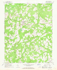 1966 Capron1968 Print · USGSSouthampton County in the mid-sixties centered on the rail-side hubs of Capron and Newsoms as timber and agriculture drove the local economy. Researchers can locate numerous country churches such as Vincent Grove Ch and Bryant Ch, or trace the winding courses of Buckhorn Swamp and Roan Swamp.3 unique versions available
 - 1966 Map of Sunbeam, 1968 Print
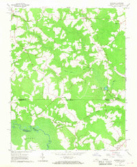 1966 Sunbeam1968 Print · USGSCoastal plain life along the Virginia and North Carolina border comes into focus in the mid-1960s. Genealogists and local historians can trace rural family hubs at Newsoms, Statesville, and Como, or locate family sites near Harts Bridge and Windbourne Millpond.2 unique versions available
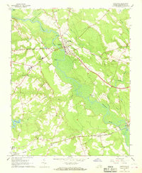
 - 1966 Map of Boykins, 1968 Print
 1966 Boykins1968 Print · USGSThe Virginia and North Carolina borderlands come to life in the 1960s, centered on the railroad crossing at Boykins. Researchers can trace the legacy of rural communities through markers like Beechwood Cem, Meherrin Sch, and the winding Meherrin River.2 unique versions available
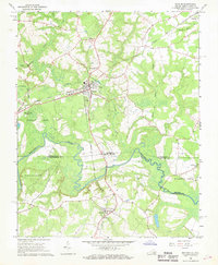
 - 1967 Map of Courtland, 1968 Print
 1967 Courtland1968 Print · USGSSouthampton County during the late sixties reveals a landscape shaped by river bends and rail lines. Researchers can trace the layout of Courtland and Newsoms or locate local landmarks like Williams Chapel and Handsom.2 unique versions available
End of results
Showing maps 1-4 of 4
Top cities near Newsoms
- Franklin historical maps
- Murfreesboro historical maps
- Courtland historical maps
- Winton historical maps
- Camptown historical maps
- Conway historical maps
See more
Frequently asked questions
- What are the different types of historical maps available for Newsoms?
- What is the oldest map of Newsoms?
- Where can I purchase historical maps of Newsoms for my home or office?
- Where can I download high-res historical maps of Newsoms?
- Are there historical topographic maps available for Newsoms?
- Is there historical aerial imagery available for Newsoms?
- Where are historical maps of Newsoms sourced from?