1970s Maps of Warren County, Virginia
Explore 8 historic maps of Warren County from the 1970s. These maps offer a rare glimpse into what life looked like during the 1970s — showing old roads, neighborhoods, homes, and landmarks that have changed or disappeared over time.
Whether you're researching your family's past, planning a metal detecting trip, or studying how Warren County's landscape evolved across the 1970s, these high-resolution maps are a powerful tool for exploring the history of this region.
- Focus on a specific era: All maps on this page are from the 1970s, giving you a focused view of this time period.
- See what’s changed: Compare century-old streets, trails, and buildings to today's modern landscape using overlays and satellite layers.
- Research with precision: Use these maps for genealogy, historical research, land use analysis, or educational projects.
- View, download, or print: Maps are fully viewable online in high resolution, and can be downloaded or printed for your own records.
Start exploring Warren County's history through authentic maps from the 1970s. This is your window into the past.
Warren County, VA maps
(8)- 1972 Map of Front Royal, 1974 Print
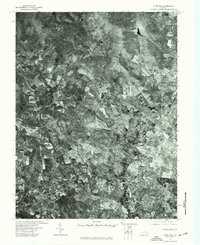
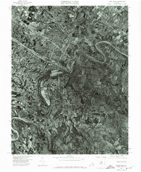 1972 Front Royal1974 Print · USGSWarren County in the early seventies is revealed through this detailed aerial survey of the Shenandoah Valley. Local historians can trace the mid-century footprint of Front Royal and the natural winding paths of the North Fork Shenandoah River and its south fork.
 - 1972 Map of Stephens City, 1977 Print
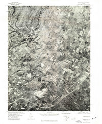
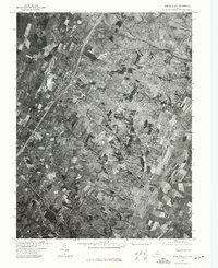 1972 Stephens City1977 Print · USGSStephens City and the surrounding Frederick County countryside are captured during the early 1970s as modern highways reshaped the valley. Trace the layout of family farms and the growth of Stephens City and Reliance through this detailed aerial photography.
 - 1972 Map of Chester Gap, 1977 Print
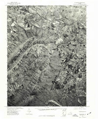
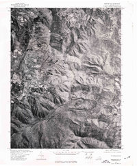 1972 Chester Gap1977 Print · USGSThe Blue Ridge foothills of northern Virginia are captured in this early 1970s aerial survey just as the landscape was beginning a new chapter of growth. Researchers can trace rural property lines and historic road patterns around Browntown and Chester Gap.
 - 1972 Map of Linden, 1977 Print
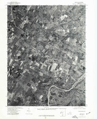
 1972 Linden1977 Print · USGSThe Blue Ridge foothills and Shenandoah Valley are revealed in this 1970s orthophotograph, capturing the area's rural character during a period of transition. Genealogists and local researchers can trace property lines and roads around Linden, Markham, and the Shenandoah River.
 - 1972 Map of Boyce, 1977 Print
 1972 Boyce1977 Print · USGSThe rural Virginia landscape of the early seventies is revealed in this aerial study centered on Clarke County. Genealogists and local historians can trace property lines and the village layouts of Boyce and Millwood near the winding Shenandoah River.
 - 1972 Map of Flint Hill, 1977 Print
 1972 Flint Hill1977 Print · USGSRappahannock and Fauquier counties are captured in the early seventies during a period of steady agricultural tradition. Researchers can trace the layout of historic crossroads settlements like Flint Hill and Hume through detailed aerial orthophotography.
 - 1972 Map of Strasburg, 1977 Print
 1972 Strasburg1977 Print · USGSStrasburg and the Shenandoah Valley are captured in high-altitude detail during the early 1970s. Local researchers can trace the winding North Fork Shenandoah River as it passes Strasburg and the rural community of Waterlick.
 - 1972 Map of Middletown, 1977 Print
 1972 Middletown1977 Print · USGSThe Shenandoah Valley comes into sharp focus during the early seventies, showing the intersection of local agriculture and community growth. Trace the winding path of Cedar Creek and the established layouts of Middletown and Lebanon Church.
End of results
Showing maps 1-8 of 8
Top cities of Warren County
- Front Royal historical maps
- Shenandoah Farms historical maps
- Apple Mountain Lake historical maps
- Shenandoah Shores historical maps
- Skyland Estates historical maps
Frequently asked questions
- What are the different types of historical maps available for Warren County?
- What is the oldest map of Warren County?
- Where can I purchase historical maps of Warren County for my home or office?
- Where can I download high-res historical maps of Warren County?
- Are there historical topographic maps available for Warren County?
- Is there historical aerial imagery available for Warren County?
- Where are historical maps of Warren County sourced from?