1960s Maps of Washington County, Virginia
Explore 8 historic maps of Washington County from the 1960s. These maps offer a rare glimpse into what life looked like during the 1960s — showing old roads, neighborhoods, homes, and landmarks that have changed or disappeared over time.
Whether you're researching your family's past, planning a metal detecting trip, or studying how Washington County's landscape evolved across the 1960s, these high-resolution maps are a powerful tool for exploring the history of this region.
- Focus on a specific era: All maps on this page are from the 1960s, giving you a focused view of this time period.
- See what’s changed: Compare century-old streets, trails, and buildings to today's modern landscape using overlays and satellite layers.
- Research with precision: Use these maps for genealogy, historical research, land use analysis, or educational projects.
- View, download, or print: Maps are fully viewable online in high resolution, and can be downloaded or printed for your own records.
Start exploring Washington County's history through authentic maps from the 1960s. This is your window into the past.
Washington County, VA maps
(8)- 1960 Map of Johnson City
 1960 Johnson City1960 Print · USGSUpper East Tennessee and the surrounding tri-state area are shown in the mid-fifties during the height of the TVA reservoir era. Trace the industrial rail lines of the Southern and Louisville and Nashville between Kingsport and Johnson City.
 - 1960 Map of Holston Valley, 1962 Print
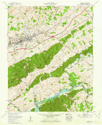
 1960 Holston Valley1962 Print · USGSSullivan County and the Virginia borderland are shown here at a moment when the recently completed South Holston Dam had transformed the river valley. Genealogists and historians can locate old landmarks like Scalf Cemetery, Sinking Spring Church, and the Bristol Caverns.4 unique versions available
 - 1960 Map of Shady Valley, 1962 Print
 1960 Shady Valley1962 Print · USGSShady Valley and the Iron Mountains are captured here in the early sixties, showing a high Appalachian basin defined by family farms and forest management. Researchers can trace family roots at Potter Cem and Crosswhite Cem or locate the old Shady Valley Sch.4 unique versions available
 - 1960 Map of Wallace, 1962 Print
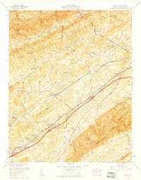
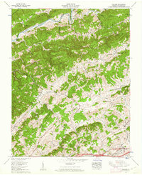 1960 Wallace1962 Print · USGSThe ridges and valleys of Washington County are captured here in the early 1960s, showing a landscape defined by the North Fork Holston River. Researchers can trace family homesteads near Benhams and Wallace or locate landmarks like Craigs Mill and Lime Hill.2 unique versions available
 - 1960 Map of Abingdon, 1962 Print
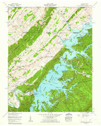
 1960 Abingdon1962 Print · USGSWashington County at the dawn of the 1960s reveals a landscape of growing towns and rising waters. Genealogists and historians can trace the foundations of Abingdon, locating Stone Mill, the Southwest Virginia 4-H Center, and the shores of South Fork Holston Lake.4 unique versions available
 - 1960 Map of Wyndale, 1962 Print
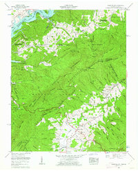
 1960 Wyndale1962 Print · USGSWestern Washington County during the early sixties shows the growth of suburbs like Preston Hills alongside long-established rural congregations. Researchers can locate family burial grounds like Pippin Cem and landmark institutions including John S Battle High School.5 unique versions available
 - 1962 Map of Winston-Salem
 1962 Winston-Salem1962 Print · USGSThe North Carolina Piedmont meets the Virginia highlands in the early sixties, showing the rail corridors and mountain gaps of the southern Appalachians. Researchers can trace the Blue Ridge Parkway or locate family sites near Winston-Salem, Mount Airy, and Hanging Rock Mountain.
 - 1963 Map of Johnson City
 1963 Johnson City1963 Print · USGSThe Tri-Cities and the surrounding Appalachian ridges are shown in detail during the early sixties, highlighting the era's vital rail and river networks. Genealogists and historians can trace the routes of the Clinchfield RR and locate settlements from Rogersville to Elizabethton.
End of results
Showing maps 1-8 of 8
Top cities of Washington County
- Abingdon historical maps
- Glade Spring historical maps
- Emory historical maps
- Damascus historical maps
- Meadowview historical maps
- Mendota historical maps
Frequently asked questions
- What are the different types of historical maps available for Washington County?
- What is the oldest map of Washington County?
- Where can I purchase historical maps of Washington County for my home or office?
- Where can I download high-res historical maps of Washington County?
- Are there historical topographic maps available for Washington County?
- Is there historical aerial imagery available for Washington County?
- Where are historical maps of Washington County sourced from?