Old Maps of Washington County, Virginia for Academic Research
Study the evolution of Washington County with 138 high-resolution historic maps. Whether you're teaching, researching, or modeling changes in land use, these maps provide essential visual documentation of urban, environmental, and geographic change.
- Analyze long-term change: Track patterns in development, transportation, and natural features.
- Ideal for environmental or urban studies: Support academic projects with primary historical map data.
- Use in the classroom or lab: Educators and researchers rely on these maps to bring historical context to life.
These maps are a powerful tool for teaching, research, and visualizing how Washington County has changed over the decades.
Washington County, VA maps
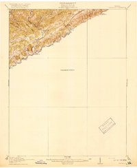
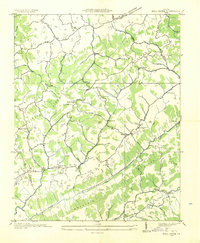
(138)- 1891 Map of Abingdon
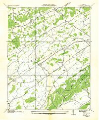
 1891 Abingdon1891 Print · USGSSouthwest Virginia in the 1890s reveals a landscape of mountain ridges and thriving valley settlements along the Norfolk and Western R. R. Lineages can be traced through sites like Emory and Henry College, Saltville, and numerous family-named landmarks like Vance's Mill.
 - 1894 Map of Abingdon, 1896 Print
 1894 Abingdon1896 Print · USGSSouthwest Virginia's valley and ridge country is captured here during the peak of the rail era, centered on the Abingdon and Marion corridors. Local historians can trace the foundations of Emory and Henry College and numerous rural mill sites like Belfast Mills or Vance's Mill.5 unique versions available
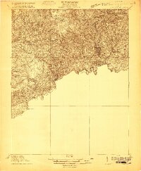
 - 1897 Map of Bristol
 1897 Bristol1897 Print · USGSThe Tennessee-Virginia borderlands in the late nineteenth century were a landscape of steep ridges and river-dependent commerce. Genealogists can trace family homesteads near Bickley Mill, locate river crossings like Childress Ferry, or find early rail stops along the Norfolk and Western RR.
 - 1902 Map of Bristol
 1902 Bristol1902 Print · USGSThe interstate border region around Bristol appears here at the start of the twentieth century, defined by its deep mountain ridges and river valleys. Researchers can trace the early industrial footprint of the area through numerous landmarks like Bickley Mill, Kings Mill, and the Norfolk and Western RR.6 unique versions available
 - 1909 Map of Abingdon
 1909 Abingdon1909 Print · USGSSouthwest Virginia at the first decade's end shows a valley landscape defined by the iron rail and steep ridges. Genealogists and historians can trace the early layouts of Abingdon and Glade Spring, or locate landmarks like Dove Mills and the County Farm.2 unique versions available
 - 1911 Map of Abingdon
 1911 Abingdon1911 Print · USGSSouthwest Virginia's rugged corridors are captured here during the height of the mountain rail era. Genealogists and historians can trace old homesteads and local landmarks such as Whites Mill, Valley Church, and the County Farm near Abingdon.5 unique versions available
 - 1918 Map of Carterton
 1918 Carterton1918 Print · USGSRussell County, Virginia, is defined by its steep coal-country ridges and the winding river corridor during the early twentieth century. Genealogists and researchers can trace the paths of the Norfolk and Western railway through Cleveland and locate vanished rural hubs like Musick School or Coulwood PO.3 unique versions available
 - 1920 Map of Coeburn
 1920 Coeburn1920 Print · USGSSouthwest Virginia during the height of its rail and timber era reveals a complex network of company towns and mountain settlements. Genealogists can trace family footprints near Dante, St Paul, and Castlewood, or locate rural institutions like the Greenwood School and Carter School.5 unique versions available
 - 1934 Map of Wallace
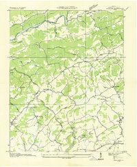 1934 Wallace1934 Print · USGSWashington County at the height of the mid-thirties reveals a landscape of ridge-top schools and valley rail depots before the post-war expansion. Researchers can trace family homesteads near Crabtree Cem or locate the old Mumpower Siding and Bristol Reservoir.
 - 1934 Map of Holston Valley
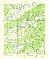
 1934 Holston Valley1934 Print · USGSThe Holston Valley was a landscape of river fords and rural outposts in the mid-1930s. Genealogists and historians can trace family ties through Stuffels Cem, locate old mills like Old Kings Mill, and find river crossings at Shady Ford.
 - 1934 Map of Brumley
 1934 Brumley1934 Print · USGSSouthwest Virginia during the mid-1930s is mapped here in detail as the TVA began its work in the Holston River watershed. Genealogists and local historians can trace rural family life through landmarks like Riverside Ch, Moccasin Gap Sch, and the river crossing at Scotts Ford.
 - 1934 Map of Hansonville
 1934 Hansonville1934 Print · USGSThe rural communities of Russell County are shown during the mid-1930s as the Tennessee Valley Authority mapped the Appalachian valleys and ridges. Genealogists and historians can locate old schools and family-linked landmarks like Millers Mill, Hawkins Mill, and Adams Chapel.
 - 1934 Map of Wyndale
 1934 Wyndale1934 Print · USGSWashington County during the mid-1930s shows a landscape of mountain ridges and fertile valleys connected by the Norfolk and Western railroad. Genealogists can trace rural life through numerous landmarks like Heavenly Rest Chapel, Needmore Sch, and the community of Wyndale.
 - 1934 Map of Bristol
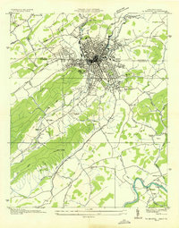 1934 Bristol1934 Print · USGSThe border-straddling community of Bristol is shown at a mid-thirties crossroads of rail and road. Local historians can trace the foundations of the area through the Bristol Landing Field, Beidleman Mill, and dozens of rural schools and churches.
 - 1935 Map of Konnarock
 1935 Konnarock1935 Print · USGSThe mountains of Southwest Virginia come alive in the mid-1930s, showing the early reach of the Unaka National Forest. Local researchers can trace family roots through sites like Konnarock, Loves Mill, and several rural schoolhouses like Piedmont Sch.
 - 1935 Map of Chilhowie
 1935 Chilhowie1935 Print · USGSSmyth County was a center of mountain industry and valley farming in the mid-1930s, defined by the Holston River forks. Researchers can trace historic family landmarks from Mathieson Alkali Works to rural centers like St Clair Bottom and Carlock Ch.
 - 1935 Map of Mendota
 1935 Mendota1935 Print · USGSThe North Fork Holston River winds through Southwest Virginia in the mid-1930s, showing a landscape shaped by rail and river. Genealogists can locate family landmarks like Fleenors Mill Ford, Marys Chapel, and Taylor Sch.
 - 1935 Map of Abingdon
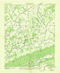
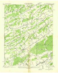
 1935 Abingdon1935 Print · USGSIn the mid-1930s, Abingdon and its surrounding Washington County landscape were shaped by the confluence of the Holston River forks and the Norfolk and Western Railway. Researchers can trace ancestral connections through rural landmarks like Knollkreg Cem, Stone Mill, and numerous country schoolhouses including Locustdale Sch and Shiloh Sch.
 - 1935 Map of Grayson
 1935 Grayson1935 Print · USGSThe high tri-state ridges of Washington County, Tennessee, and neighboring Virginia are shown here just before the mid-century. Genealogists and hikers can trace old mountain paths through Cut Laurel Gap, find the State Line Sch, and locate the Norfolk and Western rail line near Green Cove.
 - 1935 Map of Park
 1935 Park1935 Print · USGSThe high-country borderlands of North Carolina and Virginia appear here in the mid-1930s just as early aerial mapping began. Researchers can locate the mountain settlement of Park and trace the drainage of Green Creek through the Unaka National Forest.
 - 1935 Map of Blountville
 1935 Blountville1935 Print · USGSSullivan County and the Virginia borderlands are documented here in the mid-1930s, showing a rural landscape organized around the county seat and mountain ridges. Genealogists can trace family locations near Hickory Grove Sch, Linville Cave, and the Sullivan County Farm.2 unique versions available
 - 1935 Map of Mount Rogers
 1935 Mount Rogers1935 Print · USGSThe high peaks of Grayson and Smyth Counties are documented here in the mid-1930s as the Appalachian Trail was being established across Mount Rogers. Genealogists and historians can trace the foundations of mountain life at Konnarock, the Iron Mountain Boys Sch, and Taylors Valley.
 - 1935 Map of Moll Creek
 1935 Moll Creek1935 Print · USGSSouthwest Virginia ridge-and-valley life is captured here in the mid-1930s along the border of Russell and Scott counties. Researchers can trace the rural landscape through community landmarks like Lawsons Store, Point Truth, and Moll Creek Ch.
 - 1935 Map of Beaver Creek
 1935 Beaver Creek1935 Print · USGSThe border city of Bristol serves as a bustling rail and highway hub in the mid-1930s. Genealogists and historians can trace family locations near Beidleman Mill, Mountain View Cemetery, and the Twin States Fairgrounds.2 unique versions available
 - 1935 Map of Saltville
 1935 Saltville1935 Print · USGSSouthwest Virginia's industrial heart comes into focus during the mid-thirties as the salt-and-alkali economy thrives along the Holston River. Genealogists can trace the early footprint of Tumbling Creek College or locate long-standing landmarks like Belfast Mills and the Mathieson Alkali Works R R.
Showing maps 1-25 of 138
Top cities of Washington County
- Abingdon historical maps
- Glade Spring historical maps
- Emory historical maps
- Damascus historical maps
- Meadowview historical maps
- Mendota historical maps
Frequently asked questions
- What are the different types of historical maps available for Washington County?
- What is the oldest map of Washington County?
- Where can I purchase historical maps of Washington County for my home or office?
- Where can I download high-res historical maps of Washington County?
- Are there historical topographic maps available for Washington County?
- Is there historical aerial imagery available for Washington County?
- Where are historical maps of Washington County sourced from?