1930s Maps of Alum Wells, Virginia
Explore 3 historic maps of Alum Wells from the 1930s. These maps offer a rare glimpse into what life looked like during the 1930s — showing old roads, neighborhoods, homes, and landmarks that have changed or disappeared over time.
Whether you're researching your family's past, planning a metal detecting trip, or studying how Alum Wells's landscape evolved across the 1930s, these high-resolution maps are a powerful tool for exploring the history of this region.
- Focus on a specific era: All maps on this page are from the 1930s, giving you a focused view of this time period.
- See what’s changed: Compare century-old streets, trails, and buildings to today's modern landscape using overlays and satellite layers.
- Research with precision: Use these maps for genealogy, historical research, land use analysis, or educational projects.
- View, download, or print: Maps are fully viewable online in high resolution, and can be downloaded or printed for your own records.
Start exploring Alum Wells's history through authentic maps from the 1930s. This is your window into the past.
Alum Wells, VA maps
(3)- 1934 Map of Hansonville
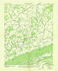 1934 Hansonville1934 Print · USGSThe rural communities of Russell County are shown during the mid-1930s as the Tennessee Valley Authority mapped the Appalachian valleys and ridges. Genealogists and historians can locate old schools and family-linked landmarks like Millers Mill, Hawkins Mill, and Adams Chapel.
 - 1938 Map of Hansonville, 1963 Print
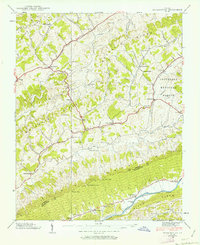 1938 Hansonville1963 Print · USGSSouthwest Virginia’s ridge-and-valley landscape is captured here in the late 1930s as local life centered on the forks of Moccasin Creek. Genealogists and historians can trace family locations near Hawkins Mill, the Davis Cemetery, and the Zenobia Post Office.3 unique versions available
 - 1939 Map of Hansonville
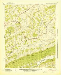 1939 Hansonville1939 Print · USGSThe rural valleys of Russell and Washington Counties are captured here in the late 1930s, showing a landscape of ridge-top trails and creek-side mills. Researchers can trace local history through sites like Zenobia PO, Miller Mill, and the McFadden Ford on the Holston River.2 unique versions available
End of results
Showing maps 1-3 of 3
Top cities near Alum Wells
- Kingsport historical maps
- Bristol historical maps
- Bristol historical maps
- Abingdon historical maps
- Lebanon historical maps
- Blountville historical maps
See more
Frequently asked questions
- What are the different types of historical maps available for Alum Wells?
- What is the oldest map of Alum Wells?
- Where can I purchase historical maps of Alum Wells for my home or office?
- Where can I download high-res historical maps of Alum Wells?
- Are there historical topographic maps available for Alum Wells?
- Is there historical aerial imagery available for Alum Wells?
- Where are historical maps of Alum Wells sourced from?