1900s (20th Century) Maps of Damascus, Virginia
Explore 12 historic maps of Damascus from the 1900s (20th Century). These maps offer a rare glimpse into what life looked like during the 1900s — showing old roads, neighborhoods, homes, and landmarks that have changed or disappeared over time.
Whether you're researching your family's past, planning a metal detecting trip, or studying how Damascus's landscape evolved across the 1900s, these high-resolution maps are a powerful tool for exploring the history of this region.
- Focus on a specific era: All maps on this page are from the 1900s, giving you a focused view of this time period.
- See what’s changed: Compare century-old streets, trails, and buildings to today's modern landscape using overlays and satellite layers.
- Research with precision: Use these maps for genealogy, historical research, land use analysis, or educational projects.
- View, download, or print: Maps are fully viewable online in high resolution, and can be downloaded or printed for your own records.
Start exploring Damascus's history through authentic maps from the 1900s. This is your window into the past.
Damascus, VA maps
(12)- 1909 Map of Abingdon
 1909 Abingdon1909 Print · USGSSouthwest Virginia at the first decade's end shows a valley landscape defined by the iron rail and steep ridges. Genealogists and historians can trace the early layouts of Abingdon and Glade Spring, or locate landmarks like Dove Mills and the County Farm.2 unique versions available
 - 1911 Map of Abingdon
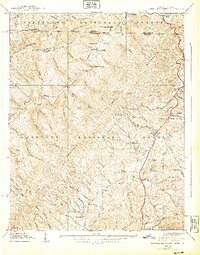
 1911 Abingdon1911 Print · USGSSouthwest Virginia's rugged corridors are captured here during the height of the mountain rail era. Genealogists and historians can trace old homesteads and local landmarks such as Whites Mill, Valley Church, and the County Farm near Abingdon.5 unique versions available
 - 1935 Map of Laurel Bloomery
 1935 Laurel Bloomery1935 Print · USGSThe Tennessee and Virginia borderlands are shown here in the mid-1930s as federal conservation efforts were taking hold in the mountains. Researchers can locate old CCC camps like Camp McArthur CCC, rural churches such as Wesley Chapel, and the original path of the Appalachian Trail.
 - 1935 Map of Damascus
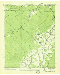
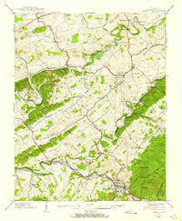
 1935 Damascus1935 Print · USGSWashington County during the mid-thirties shows a rural landscape at the intersection of river power and mountain wilderness. Genealogists can trace early homesteads and community hubs like Vestal P O, DeBusk Mill, and Oak Hill Cem across Rhea Valley.
 - 1935 Map of River Knobs
 1935 River Knobs1935 Print · USGSThe Virginia and Tennessee borderlands come alive in the mid-1930s, showing a landscape of river forks and mountain ridges. Trace the early Appalachian Trail, locate Great Depression-era sites like CCC Camp Shelby, and find family history at Knotts Cem.
 - 1938 Map of Laurel Bloomery
 1938 Laurel Bloomery1938 Print · USGSThe Tennessee-Virginia borderlands near Johnson County come alive in this late 1930s survey of the mountain gaps and forest camps. Genealogists can trace family lines through Gentry Cem and Cornett Cem or locate old community hubs like Laurel Bloomery and CCC Camp Mc Arthur.5 unique versions available
 - 1938 Map of Damascus
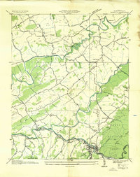
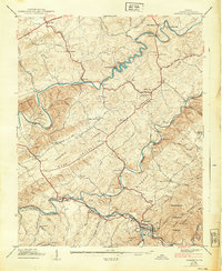
 1938 Damascus1938 Print · USGSSouthwest Virginia's valley and mountain landscapes are captured here in the late 1930s as rural industry and transport intersected at Damascus. Researchers can locate vanished rural infrastructure like De Busk Mill, the Appalachian Trail, and the Drowning Ford Vestal (P O).3 unique versions available
 - 1939 Map of Damascus
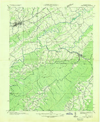
 1939 Damascus1939 Print · USGSWashington County at the end of the 1930s shows a landscape of mountain river industry and valley farmsteads. Trace early milling sites like De Busk Mill, the post office at Vestal (P O), and old country schools like Beech Grove Sch.
 - 1953 Map of Winston-Salem, 1974 Print
 1953 Winston-Salem1974 Print · USGSThe North Carolina Piedmont and Virginia highlands meet in the mid-1950s, a landscape defined by the tobacco and textile hubs of the Blue Ridge foothills. Researchers can trace the rail-and-river geography connecting Winston-Salem to mountain towns like Mount Airy and Galax.2 unique versions available
 - 1955 Map of Winston-Salem
 1955 Winston-Salem1955 Print · USGSThe Central Blue Ridge and Piedmont transition are captured here in the mid-fifties, from the industrial hub of Winston-Salem to the high peaks of Southwest Virginia. Genealogists can trace family landmarks like Richmond Hill Ch, Siloam Ch, and the old rail stops along the Southern Railway.
 - 1962 Map of Winston-Salem
 1962 Winston-Salem1962 Print · USGSThe North Carolina Piedmont meets the Virginia highlands in the early sixties, showing the rail corridors and mountain gaps of the southern Appalachians. Researchers can trace the Blue Ridge Parkway or locate family sites near Winston-Salem, Mount Airy, and Hanging Rock Mountain.
 - 1982 Map of Wytheville, 1983 Print
 1982 Wytheville1983 Print · USGSSouthwest Virginia's ridge-and-valley landscape is shown here in the early 1980s as the Interstate era fully connected the region. Genealogists and historians can trace family locations near Emory and Henry College, the historic Austinville Mine, and settlements like Saltville or Lansing.3 unique versions available
End of results
Showing maps 1-12 of 12
Top cities near Damascus
- Abingdon historical maps
- Mountain City historical maps
- Saltville historical maps
- Chilhowie historical maps
- Glade Spring historical maps
- Emory historical maps
See more
Frequently asked questions
- What are the different types of historical maps available for Damascus?
- What is the oldest map of Damascus?
- Where can I purchase historical maps of Damascus for my home or office?
- Where can I download high-res historical maps of Damascus?
- Are there historical topographic maps available for Damascus?
- Is there historical aerial imagery available for Damascus?
- Where are historical maps of Damascus sourced from?