1930s Maps of Mongle Spring, Virginia
Explore 3 historic maps of Mongle Spring from the 1930s. These maps offer a rare glimpse into what life looked like during the 1930s — showing old roads, neighborhoods, homes, and landmarks that have changed or disappeared over time.
Whether you're researching your family's past, planning a metal detecting trip, or studying how Mongle Spring's landscape evolved across the 1930s, these high-resolution maps are a powerful tool for exploring the history of this region.
- Focus on a specific era: All maps on this page are from the 1930s, giving you a focused view of this time period.
- See what’s changed: Compare century-old streets, trails, and buildings to today's modern landscape using overlays and satellite layers.
- Research with precision: Use these maps for genealogy, historical research, land use analysis, or educational projects.
- View, download, or print: Maps are fully viewable online in high resolution, and can be downloaded or printed for your own records.
Start exploring Mongle Spring's history through authentic maps from the 1930s. This is your window into the past.
Mongle Spring, VA maps
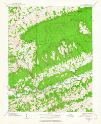
(3)- 1934 Map of Brumley
 1934 Brumley1934 Print · USGSSouthwest Virginia during the mid-1930s is mapped here in detail as the TVA began its work in the Holston River watershed. Genealogists and local historians can trace rural family life through landmarks like Riverside Ch, Moccasin Gap Sch, and the river crossing at Scotts Ford.
 - 1938 Map of Brumley, 1965 Print
 1938 Brumley1965 Print · USGSSouthwest Virginia in the late thirties is defined here by mountain gaps and river crossings. Genealogists can trace the rural life of Poor Valley through landmarks like the Phelps Cem, Moccasin Gap Sch, and the State Prison Camp.4 unique versions available
 - 1939 Map of Brumley
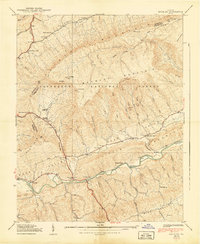 1939 Brumley1939 Print · USGSSouthwest Virginia's ridge-and-valley landscape is captured here in the late 1930s as rural life centered on the North Fork Holston River. Researchers can locate family landmarks such as Phelps Cem, Green Valley Ch, and the Moccasin Gap Sch near the Jefferson National Forest boundary.2 unique versions available
End of results
Showing maps 1-3 of 3
Top cities near Mongle Spring
- Bristol historical maps
- Bristol historical maps
- Abingdon historical maps
- Lebanon historical maps
- Walnut Hill historical maps
- Emory historical maps
See more
Frequently asked questions
- What are the different types of historical maps available for Mongle Spring?
- What is the oldest map of Mongle Spring?
- Where can I purchase historical maps of Mongle Spring for my home or office?
- Where can I download high-res historical maps of Mongle Spring?
- Are there historical topographic maps available for Mongle Spring?
- Is there historical aerial imagery available for Mongle Spring?
- Where are historical maps of Mongle Spring sourced from?