1960s Maps of Colonial Beach, Virginia
Explore 4 historic maps of Colonial Beach from the 1960s. These maps offer a rare glimpse into what life looked like during the 1960s — showing old roads, neighborhoods, homes, and landmarks that have changed or disappeared over time.
Whether you're researching your family's past, planning a metal detecting trip, or studying how Colonial Beach's landscape evolved across the 1960s, these high-resolution maps are a powerful tool for exploring the history of this region.
- Focus on a specific era: All maps on this page are from the 1960s, giving you a focused view of this time period.
- See what’s changed: Compare century-old streets, trails, and buildings to today's modern landscape using overlays and satellite layers.
- Research with precision: Use these maps for genealogy, historical research, land use analysis, or educational projects.
- View, download, or print: Maps are fully viewable online in high resolution, and can be downloaded or printed for your own records.
Start exploring Colonial Beach's history through authentic maps from the 1960s. This is your window into the past.
Colonial Beach, VA maps
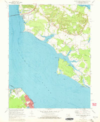
(4)- 1961 Map of Washington
 1961 Washington1961 Print · USGSThe mid-Atlantic region in the late fifties is presented in remarkable detail, from the Blue Ridge foothills to the Chesapeake Eastern Shore. Researchers can trace historic river landings and military sites like Mount Vernon, Fort Belvoir, and Point Lookout.2 unique versions available
 - 1968 Map of Colonial Beach South, 1971 Print
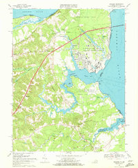
 1968 Colonial Beach South1971 Print · USGSThe Westmoreland County tidewater is preserved here in the late sixties, where presidential history meets the Potomac shoreline. Researchers can trace ancestral sites like Wakefield Mansion or explore rural crossroads such as Monroe Hall and Potomac Mills.4 unique versions available
 - 1968 Map of Dahlgren, 1972 Print
 1968 Dahlgren1972 Print · USGSThe northern neck of Virginia in the late sixties reveals a landscape of high-tech naval defense and deep-rooted rural communities. Trace the grounds of the Dahlgren Weapons Laboratory or locate family sites like Bumbry Cem and Carruthers Corner.2 unique versions available
 - 1968 Map of Colonial Beach North, 1972 Print
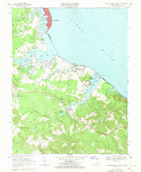
 1968 Colonial Beach North1972 Print · USGSThe Potomac River shoreline in Maryland and Virginia comes alive in the late sixties, showcasing the riverside culture and industry of the day. Trace family roots at Old Christ Ch or Holy Ghost Ch, and explore the coastal layout of Colonial Beach and Morgantown.5 unique versions available
End of results
Showing maps 1-4 of 4
Top cities near Colonial Beach
- King George historical maps
- Dahlgren historical maps
- Cobb Island historical maps
- Dahlgren Center historical maps
- Montross historical maps
- Port Royal historical maps
See more
Top neighborhoods of Colonial Beach
Frequently asked questions
- What are the different types of historical maps available for Colonial Beach?
- What is the oldest map of Colonial Beach?
- Where can I purchase historical maps of Colonial Beach for my home or office?
- Where can I download high-res historical maps of Colonial Beach?
- Are there historical topographic maps available for Colonial Beach?
- Is there historical aerial imagery available for Colonial Beach?
- Where are historical maps of Colonial Beach sourced from?