1950s Maps of Williamsburg, Virginia
Explore 5 historic maps of Williamsburg from the 1950s. These maps offer a rare glimpse into what life looked like during the 1950s — showing old roads, neighborhoods, homes, and landmarks that have changed or disappeared over time.
Whether you're researching your family's past, planning a metal detecting trip, or studying how Williamsburg's landscape evolved across the 1950s, these high-resolution maps are a powerful tool for exploring the history of this region.
- Focus on a specific era: All maps on this page are from the 1950s, giving you a focused view of this time period.
- See what’s changed: Compare century-old streets, trails, and buildings to today's modern landscape using overlays and satellite layers.
- Research with precision: Use these maps for genealogy, historical research, land use analysis, or educational projects.
- View, download, or print: Maps are fully viewable online in high resolution, and can be downloaded or printed for your own records.
Start exploring Williamsburg's history through authentic maps from the 1950s. This is your window into the past.
Williamsburg, VA maps
(5)- 1950 Map of Cobham Bay, 1953 Print
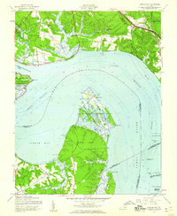
 1950 Cobham Bay1953 Print · USGSThe James River waterfront is frozen in time at mid-century, showing the early boundaries of the Colonial National Historical Monument. Researchers can trace the rural landscape from Jamestown Island to the remote lighthouses at Homewood and Deepwater Shoals.
 - 1951 Map of Williamsburg
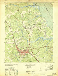 1951 Williamsburg1951 Print · USGSMid-century Williamsburg and York County reflect a landscape of deep colonial history overlaid by World War II-era military expansion. Researchers can trace the grounds of William and Mary College and the Governors Palace alongside major naval installations like Camp Peary and the Cheatham Annex.
 - 1952 Map of Williamsburg, 1957 Print
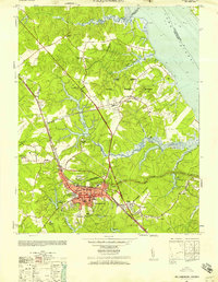 1952 Williamsburg1957 Print · USGSThe Virginia Peninsula is captured here in the early fifties during a period of heavy military and institutional expansion. Researchers can trace the grounds of William and Mary College, find the Fort Magruder Ruins, and locate forgotten landings like Blaine Landing.
 - 1957 Map of Cobham Bay, 1960 Print
 1957 Cobham Bay1960 Print · USGSThe James River coastline in the late fifties was a mix of historic preservation and active military defense. Trace the development of Hog Island State Waterfowl Refuge and locate old family sites like Travis Cem and Chippokes.
 - 1959 Map of Richmond
 1959 Richmond1959 Print · USGSMid-century Virginia is captured here at its most vital rail and river junctions, from the capital city to the Chesapeake Bay. Genealogists and historians can trace the development of colonial settlements like Williamsburg and military landmarks including Fort Monroe and Camp Lee.
End of results
Showing maps 1-5 of 5
Top cities of Williamsburg
Frequently asked questions
- What are the different types of historical maps available for Williamsburg?
- What is the oldest map of Williamsburg?
- Where can I purchase historical maps of Williamsburg for my home or office?
- Where can I download high-res historical maps of Williamsburg?
- Are there historical topographic maps available for Williamsburg?
- Is there historical aerial imagery available for Williamsburg?
- Where are historical maps of Williamsburg sourced from?