1930s Maps of Pound, Virginia
Explore 2 historic maps of Pound from the 1930s. These maps offer a rare glimpse into what life looked like during the 1930s — showing old roads, neighborhoods, homes, and landmarks that have changed or disappeared over time.
Whether you're researching your family's past, planning a metal detecting trip, or studying how Pound's landscape evolved across the 1930s, these high-resolution maps are a powerful tool for exploring the history of this region.
- Focus on a specific era: All maps on this page are from the 1930s, giving you a focused view of this time period.
- See what’s changed: Compare century-old streets, trails, and buildings to today's modern landscape using overlays and satellite layers.
- Research with precision: Use these maps for genealogy, historical research, land use analysis, or educational projects.
- View, download, or print: Maps are fully viewable online in high resolution, and can be downloaded or printed for your own records.
Start exploring Pound's history through authentic maps from the 1930s. This is your window into the past.
Pound, VA maps
(2)- 1935 Map of Indian Gap
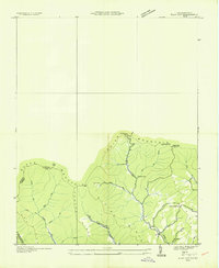
 1935 Indian Gap1935 Print · USGSWise County is shown during a period of coal-driven growth in the mid-1930s. Researchers can trace the industrial landscape of Clinchfield Coal No 14 and the local community around Glamorgan, Vickers, and the Gilliam Sch.
 - 1935 Map of Flat Gap
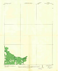
 1935 Flat Gap1935 Print · USGSThe high ridges of the Appalachians meet at the Virginia and Kentucky border during the mid-1930s. Genealogists and local historians can trace family land via Steve Horn Branch, locate the Hunsucker Sch, or follow the old Powell Mc Corkle Lumber Company Tramway.
End of results
Showing maps 1-2 of 2
Top cities near Pound
- Norton historical maps
- Wise historical maps
- Jenkins historical maps
- Whitesburg historical maps
- Coeburn historical maps
- Appalachia historical maps
See more
Top neighborhoods of Pound
Frequently asked questions
- What are the different types of historical maps available for Pound?
- What is the oldest map of Pound?
- Where can I purchase historical maps of Pound for my home or office?
- Where can I download high-res historical maps of Pound?
- Are there historical topographic maps available for Pound?
- Is there historical aerial imagery available for Pound?
- Where are historical maps of Pound sourced from?