1940s Maps of Anatone, Washington
Explore 2 historic maps of Anatone from the 1940s. These maps offer a rare glimpse into what life looked like during the 1940s — showing old roads, neighborhoods, homes, and landmarks that have changed or disappeared over time.
Whether you're researching your family's past, planning a metal detecting trip, or studying how Anatone's landscape evolved across the 1940s, these high-resolution maps are a powerful tool for exploring the history of this region.
- Focus on a specific era: All maps on this page are from the 1940s, giving you a focused view of this time period.
- See what’s changed: Compare century-old streets, trails, and buildings to today's modern landscape using overlays and satellite layers.
- Research with precision: Use these maps for genealogy, historical research, land use analysis, or educational projects.
- View, download, or print: Maps are fully viewable online in high resolution, and can be downloaded or printed for your own records.
Start exploring Anatone's history through authentic maps from the 1940s. This is your window into the past.
Anatone, WA maps
(2)- 1944 Map of Anatone, 1959 Print
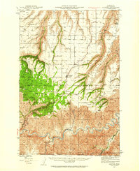 1944 Anatone1959 Print · USGSAsotin County high country in the mid-1940s reveals a landscape of deep canyons and high ranching plateaus above the Grande Ronde River. Researchers can trace old upland sites like the Ausman Ranch, the rural Lake Sch, and the fire lookout at Big Butte.
 - 1946 Map of Anatone
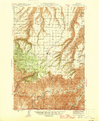 1946 Anatone1946 Print · USGSAsotin County ranching and timberlands are captured here in the mid-1940s, from the high Anatone plateau down to the deep river canyons. Genealogists and historians can locate the Ausman Ranch, Lake Sch, and the Big Butte Lookout.
End of results
Showing maps 1-2 of 2
Top cities near Anatone
Frequently asked questions
- What are the different types of historical maps available for Anatone?
- What is the oldest map of Anatone?
- Where can I purchase historical maps of Anatone for my home or office?
- Where can I download high-res historical maps of Anatone?
- Are there historical topographic maps available for Anatone?
- Is there historical aerial imagery available for Anatone?
- Where are historical maps of Anatone sourced from?