1900s (20th Century) Maps of Benton City, Washington
Explore 11 historic maps of Benton City from the 1900s (20th Century). These maps offer a rare glimpse into what life looked like during the 1900s — showing old roads, neighborhoods, homes, and landmarks that have changed or disappeared over time.
Whether you're researching your family's past, planning a metal detecting trip, or studying how Benton City's landscape evolved across the 1900s, these high-resolution maps are a powerful tool for exploring the history of this region.
- Focus on a specific era: All maps on this page are from the 1900s, giving you a focused view of this time period.
- See what’s changed: Compare century-old streets, trails, and buildings to today's modern landscape using overlays and satellite layers.
- Research with precision: Use these maps for genealogy, historical research, land use analysis, or educational projects.
- View, download, or print: Maps are fully viewable online in high resolution, and can be downloaded or printed for your own records.
Start exploring Benton City's history through authentic maps from the 1900s. This is your window into the past.
Benton City, WA maps
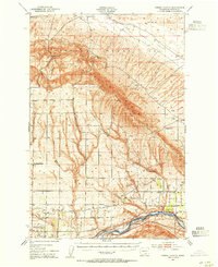
(11)- 1915 Map of Prosser, 1957 Print
 1915 Prosser1957 Print · USGSThe Yakima Valley thrived as a rail and irrigation hub during the early twentieth century. Researchers can trace the layout of early schools and family-named homesteads like Orchard Ridge School, Snively Ranch, and the town of Prosser.
 - 1917 Map of Pasco
 1917 Pasco1917 Print · USGSThe confluence of the Columbia and Snake rivers in the early twentieth century shows a region being reshaped by irrigation and rail. Genealogists can trace family holdings and rural schoolhouses like Baxter School, the Farnsworth Ranch, and the Zimmerman Ferry.4 unique versions available
 - 1917 Map of Prosser
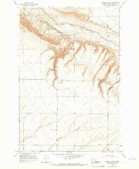
 1917 Prosser1917 Print · USGSBenton and Yakima counties thrive in the late teens as irrigation and rail lines transform the desert floor into a budding agricultural hub. Researchers can trace early family homesteads like Benson Ranch and numerous rural landmarks like Buena Vista School and the Gas Well.2 unique versions available
 - 1951 Map of Richland, 1955 Print
 1951 Richland1955 Print · USGSBenton County undergoes a massive industrial shift during the early Cold War era as the atomic age reshapes the desert landscape. You can trace the early footprint of the Hanford Works, the growth of RICHLAND, and the vital irrigation systems like the Columbia Canal.3 unique versions available
 - 1951 Map of Corral Canyon, 1955 Print
 1951 Corral Canyon1955 Print · USGSBenton County at the height of the Cold War reveals a landscape shaped by both the atomic age and deep-rooted agriculture. Genealogists and historians can locate family landmarks like Benson Ranch, the settlement of Chaffee (Old Glen), and the vast Hanford Works (A. E. C.) reservation.3 unique versions available
 - 1953 Map of Walla Walla, 1964 Print
 1953 Walla Walla1964 Print · USGSSoutheast Washington enters the atomic and hydroelectric age in the mid-twentieth century as new dams reshape the desert landscape. You can trace the development of the Hanford Works, identify remote rail stops like Novara Siding, and locate the historic Dry Creek Cem.3 unique versions available
 - 1958 Map of Walla Walla
 1958 Walla Walla1958 Print · USGSThe Tri-Cities and Walla Walla region are captured here during the mid-century expansion of atomic energy and river infrastructure. Genealogists and historians can trace the early layout of Richland (AEC), the rural Hatton and Washtucna settlements, and landmarks like Palouse Falls State Park.
 - 1965 Map of Weber Canyon, 1966 Print
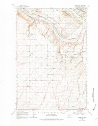
 1965 Weber Canyon1966 Print · USGSBenton County agriculture and upland terrain are on display here in the mid-1960s as irrigation canals began to transform the dry landscape. Researchers can locate the Cemetery on Travis Cemetery Road and trace rural life through landmarks like the Grain Elevator and the Landing Strip.
 - 1965 Map of Badger Mtn, 1982 Print
 1965 Badger Mtn1982 Print · USGSBenton County agriculture and rail infrastructure are captured here in the mid-1960s as irrigation systems transformed the valley. Genealogists can trace family holdings along Reese Road, locate the Cemetery near Cemetery Road, or find the Grange Hall and Coyote Springs.
 - 1974 Map of Benton City, 1977 Print
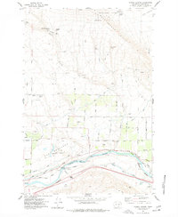
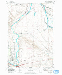 1974 Benton City1977 Print · USGSBenton City and Kiona sit at a vital river bend in the 1970s, where rail lines and irrigation canals meet the shadow of Red Mountain. Genealogists and local historians can trace the foundations of the community through Evergreen Cem, the Kiona-Benton City Sch, and the sprawling Hanford Works boundary.
 - 1977 Map of Corral Canyon
 1977 Corral Canyon1977 Print · USGSIn the arid landscape of Benton County during the late 1970s, the desert meets industrial utility along the river. Trace the irrigation networks of the Roza Canal and find family-named sites like McWhorter Ranch and Katie Fleck Spring.
End of results
Showing maps 1-11 of 11
Top cities near Benton City
Frequently asked questions
- What are the different types of historical maps available for Benton City?
- What is the oldest map of Benton City?
- Where can I purchase historical maps of Benton City for my home or office?
- Where can I download high-res historical maps of Benton City?
- Are there historical topographic maps available for Benton City?
- Is there historical aerial imagery available for Benton City?
- Where are historical maps of Benton City sourced from?