Old Maps of La Push, Washington for Academic Research
Study the evolution of La Push with 8 high-resolution historic maps. Whether you're teaching, researching, or modeling changes in land use, these maps provide essential visual documentation of urban, environmental, and geographic change.
- Analyze long-term change: Track patterns in development, transportation, and natural features.
- Ideal for environmental or urban studies: Support academic projects with primary historical map data.
- Use in the classroom or lab: Educators and researchers rely on these maps to bring historical context to life.
These maps are a powerful tool for teaching, research, and visualizing how La Push has changed over the decades.
La Push, WA maps
(8)- 1943 Map of Copalis Beach
 1943 Copalis Beach1943 Print · USGSThe Washington coast in the 1940s is detailed here from the Olympic Peninsula to the Columbia River. Trace old beach settlements like Moclips and Copalis Beach alongside landmarks like the Willapa Bay Lighthouse.
 - 1951 Map of Copalis Beach
 1951 Copalis Beach1951 Print · USGSThe Olympic Peninsula's rugged coast and tribal lands are meticulously detailed in the early 1950s. Genealogists and historians can trace the foundations of coastal communities from Taholah to La Push or locate early markers like the James Island Lighthouse.
 - 1956 Map of La Push, 1960 Print
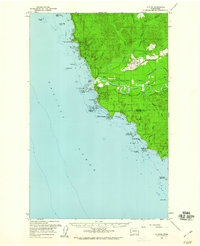 1956 La Push1960 Print · USGSCoastal Clallam County comes into focus in the mid-1950s as a hub for military aviation and the timber industry. Researchers can trace the legacy of the Quillayute Outlying Field Naval Res, the Logging RR, and the Chilean Memorial Mon along the Pacific.3 unique versions available
 - 1957 Map of Copalis Beach, 1968 Print
 1957 Copalis Beach1968 Print · USGSThe Washington coast during the late fifties reveals a landscape of tribal reservations and timber towns linked by the Northern Pacific RR. Trace family history and land patterns near Forks Cemetery, the shingle mill, or coastal landings like Taholah and Oysterville.2 unique versions available
 - 1963 Map of Copalis Beach
 1963 Copalis Beach1963 Print · USGSThe Washington coast in the early sixties reveals a landscape of massive timber reserves, indigenous lands, and quiet seaside villages. Genealogists and historians can trace the foundations of coastal life through sites like Lone Fir Cemetery, the Dismantled RR, and the historic oyster beds of Oysterville.
 - 1982 Map of La Push
 1982 La Push1982 Print · USGSCoastal Clallam County in the early eighties shows the intersection of tribal lands and federal wilderness at the mouth of the Quillayute River. Local historians can trace the development of La Push including its US Coast Guard Station and the Chilean Memorial Monument.2 unique versions available
 - 1988 Map of Forks
 1988 Forks1988 Print · USGSThe Olympic Peninsula's western coastline and timber heartland are documented here in the late eighties, from the high ridges to the Pacific shelf. Local researchers can trace the coastal settlements of La Push and Mora or locate remote sites like Destruction Island.
 - 2023 Map of La Push, 2023 Print
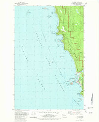
 2023 La Push2023 Print · USGSThe Quileute coast and the village of La Push are documented here in the early twenty-first century. Researchers can trace the rugged shoreline from Rialto Beach to First Beach and locate offshore landmarks like James Island and Cake Rock.
End of results
Showing maps 1-8 of 8
Top cities near La Push
Frequently asked questions
- What are the different types of historical maps available for La Push?
- What is the oldest map of La Push?
- Where can I purchase historical maps of La Push for my home or office?
- Where can I download high-res historical maps of La Push?
- Are there historical topographic maps available for La Push?
- Is there historical aerial imagery available for La Push?
- Where are historical maps of La Push sourced from?