1990s Maps of Greater Brush Prairie, Clark County
Explore 4 historic maps of Greater Brush Prairie from the 1990s. These maps offer a rare glimpse into what life looked like during the 1990s — showing old roads, neighborhoods, homes, and landmarks that have changed or disappeared over time.
Whether you're researching your family's past, planning a metal detecting trip, or studying how Greater Brush Prairie's landscape evolved across the 1990s, these high-resolution maps are a powerful tool for exploring the history of this region.
- Focus on a specific era: All maps on this page are from the 1990s, giving you a focused view of this time period.
- See what’s changed: Compare century-old streets, trails, and buildings to today's modern landscape using overlays and satellite layers.
- Research with precision: Use these maps for genealogy, historical research, land use analysis, or educational projects.
- View, download, or print: Maps are fully viewable online in high resolution, and can be downloaded or printed for your own records.
Start exploring Greater Brush Prairie's history through authentic maps from the 1990s. This is your window into the past.
Greater Brush Prairie, Clark County maps
(4)- 1990 Map of Lacamas Creek, 1995 Print
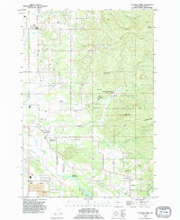 1990 Lacamas Creek1995 Print · USGSNortheast of Vancouver in the early nineties, this area shows a landscape defined by military land and rural crossroads. Genealogists and researchers can trace local landmarks from Hockinson and Fern Prairie to industrial sites like the English Pit and Grove Field.
 - 1990 Map of Yacolt, 1995 Print
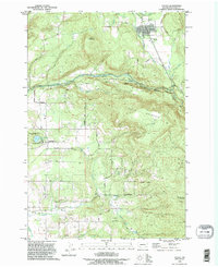 1990 Yacolt1995 Print · USGSYacolt and the East Fork Lewis River are captured here during the 1990s as the region balanced timber heritage with growing recreation. Genealogists and researchers can trace the locations of the Gravel Point Cemetery, Finn Hill Cemetery, and the old settlement of Venersborg.
 - 1990 Map of Orchards, 1995 Print
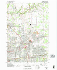 1990 Orchards1995 Print · USGSGreater Vancouver and the Fourth Plains area appear here in the early nineties as the suburban grid expands into traditional farmland. Genealogists and local researchers can locate family sites at St Johns Cem, Elim Ch, and the long-established settlement of Brush Prairie.
 - 1990 Map of Battle Ground, 1995 Print
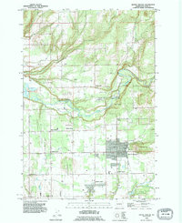 1990 Battle Ground1995 Print · USGSBattle Ground and its surrounding Clark County rural communities are captured here in the early nineties during a period of steady growth. Researchers can trace ancestral roots and old property lines near Dublin Cemetery, Charter Oak, and the distinctive family-named crossroads of King Corner.
End of results
Showing maps 1-4 of 4
Frequently asked questions
- What are the different types of historical maps available for Greater Brush Prairie?
- What is the oldest map of Greater Brush Prairie?
- Where can I purchase historical maps of Greater Brush Prairie for my home or office?
- Where can I download high-res historical maps of Greater Brush Prairie?
- Are there historical topographic maps available for Greater Brush Prairie?
- Is there historical aerial imagery available for Greater Brush Prairie?
- Where are historical maps of Greater Brush Prairie sourced from?