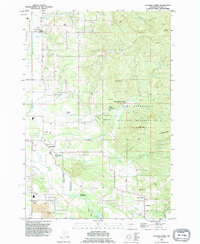
1990 Map of Lacamas Creek
USGS Topo · Published 1995About this map
Camp Bonneville Military Reservation dominates the eastern hills of this Clark County landscape, a reminder of the region's mid-century tactical and training history. Settled pockets like Hockinson and Proebstel anchor the western flats, where the terrain transitions from agricultural fields to the rising slopes of Elkhorn Mountain and Livingston Mountain. The map reveals a diversified local economy ranging from the aviation activity at Grove Field to industrial operations at the English Pit and various other gravel pits. Water is a defining element throughout, with the drainage of Shanghai Creek and Matney Creek feeding toward the recreational and natural basin of Lacamas Lake at the southern margin. This survey captures a moment when rural crossroads and timbered uplands were increasingly intersected by specialized land uses, including the Lacamas Campground and the residential layout of a Mobile Home Park.
Find a feature on this map
33 named features on this map. Tap any name to fly to it.
Don’t see what you’re looking for? This feature index may not catch every label — zoom into the map to look around manually.
Map Details
Editions of this 1990 Lacamas Creek Map
This is the sole edition of this map. No revisions or reprints were ever made.
Other maps of this area

1897 · Portland
USGS Topo · 1:62,500

1905 · Portland
USGS Topo · 1:62,500

1918 · Troutdale
USGS Topo · 1:62,500

1934 · Troutdale
USGS Topo · 1:48,000

1940 · Portland
USGS Topo · 1:62,500

1940 · La Center
USGS Topo · 1:62,500

1941 · Yacolt
USGS Topo · 1:62,500

1941 · Camas
USGS Topo · 1:62,500

1942 · Camas
USGS Topo · 1:62,500

1948 · Vancouver
USGS Topo · 1:250,000