1940 Map of La Center
USGS Topo · Published 1940About this map
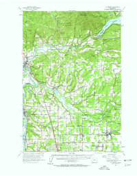
Lewis River meanders across this pre-war landscape, connecting the high waters of Lake Merwin in the northeast to the settlements of Woodland and La Center. The area is defined by a network of small agricultural and timber communities, including Battleground, Ridgefield, and Cherry Grove. The 91st Observation Squadron provided aerial photography for this 1939-1940 study, capturing the early alignment of the Pacific Highway and localized infrastructure like the State Fish Hatchery near Etna.
Find a feature on this map
43 named features on this map. Tap any name to fly to it.
Don’t see what you’re looking for? This feature index may not catch every label — zoom into the map to look around manually.
Map Details
Editions of this 1940 La Center Map
This is the sole edition of this map. No revisions or reprints were ever made.