
Loading...
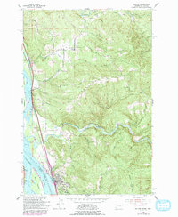
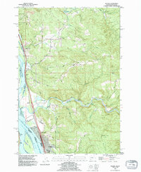
Loading map...1921 Map of Kalama
USGS Topo · Published 1921About this map
The Columbia River serves as the dominant spine of this 1921 tactical reconnaissance, carving a broad path between Washington and Oregon. This era captures the region's heavy reliance on both water and rail transportation, with the Northern Pacific Ry and Spokane Portland & Seattle RR flanking the riverbanks. Early automotive infrastructure is also visible via the Pacific Highway and Columbia River Highway, tracing the transition from steam to internal combustion.
Find a feature on this map
34 named features on this map. Tap any name to fly to it.
Don’t see what you’re looking for? This feature index may not catch every label — zoom into the map to look around manually.
Map Details
Date Portrayed1921
Date Published1921
PublisherU.S. Geological Survey
Map TypeTopographic
Scale1:62,500
Physical Dimensions15.02 x 21.15 inches
Editions of this 1921 Kalama Map
This is the sole edition of this map. No revisions or reprints were ever made.
Historical Maps of Longview Through Time
4 maps found

Featured Locations
Source Details
SourceU.S. Geological Survey
CopyrightPublic Domain