
1941 Map of Olequa
USGS Topo · Published 1941About this map
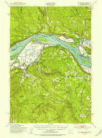
The Cowlitz River corridor anchors this tactical survey, tracing the intricate connection between the river valley and the Northern Pacific railroad as it passes through Winlock, Vader, and Castle Rock. The landscape reveals a deeply rooted rural community, highlighted by religious and educational institutions such as St Marys Academy, St Francis Mission, and several local schools like the Ainslie School.
Find a feature on this map
44 named features on this map. Tap any name to fly to it.
Don’t see what you’re looking for? This feature index may not catch every label — zoom into the map to look around manually.
Map Details
Editions of this 1941 Olequa Map
This is the sole edition of this map. No revisions or reprints were ever made.
Other maps of this area

1916 · Chehalis
USGS Topo · 1:125,000

1919 · Mayger
USGS Topo · 1:62,500

1921 · Kalama
USGS Topo · 1:62,500

1941 · Meskill
USGS Topo · 1:62,500

1941 · Clatskanie
USGS Topo · 1:62,500

1942 · Toutle
USGS Topo · 1:62,500

1943 · Willapa
USGS Topo · 1:62,500

1943 · Pigeon Springs
USGS Topo · 1:62,500
1952 · Clatskanie
USGS Topo · 1:62,500

1953 · Hoquiam
USGS Topo · 1:250,000