
1943 Map of Pigeon Springs
USGS Topo · Published 1943About this map
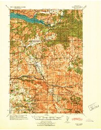
Pigeon Springs and its surrounding watershed are documented here during the early 1940s, a period when the timber and water resources of Cowlitz County were being heavily utilized. The map illustrates a landscape of working ranches and river engineering, featuring several small dams such as the Mulholland Creek Dam, Coweeman River Dam, and Baird Creek Dam. The presence of the Coweeman CCC Camp reflects Depression-era infrastructure work that continued to shape the region's management into the war years.
Find a feature on this map
51 named features on this map. Tap any name to fly to it.
Don’t see what you’re looking for? This feature index may not catch every label — zoom into the map to look around manually.
Map Details
Editions of this 1943 Pigeon Springs Map
This is the sole edition of this map. No revisions or reprints were ever made.
Other maps of this area

1919 · Mount St Helens
USGS Topo · 1:125,000

1921 · Kalama
USGS Topo · 1:62,500

1922 · St. Helens
USGS Topo · 1:62,500

1940 · La Center
USGS Topo · 1:62,500
1941 · Yacolt
USGS Topo · 1:62,500

1941 · St Helens
USGS Topo · 1:62,500

1941 · Olequa
USGS Topo · 1:62,500

1942 · Toutle
USGS Topo · 1:62,500

1943 · St Helens
USGS Topo · 1:62,500

1948 · Vancouver
USGS Topo · 1:250,000