1990s Maps of Kalama, Washington
Explore 2 historic maps of Kalama from the 1990s. These maps offer a rare glimpse into what life looked like during the 1990s — showing old roads, neighborhoods, homes, and landmarks that have changed or disappeared over time.
Whether you're researching your family's past, planning a metal detecting trip, or studying how Kalama's landscape evolved across the 1990s, these high-resolution maps are a powerful tool for exploring the history of this region.
- Focus on a specific era: All maps on this page are from the 1990s, giving you a focused view of this time period.
- See what’s changed: Compare century-old streets, trails, and buildings to today's modern landscape using overlays and satellite layers.
- Research with precision: Use these maps for genealogy, historical research, land use analysis, or educational projects.
- View, download, or print: Maps are fully viewable online in high resolution, and can be downloaded or printed for your own records.
Start exploring Kalama's history through authentic maps from the 1990s. This is your window into the past.
Kalama, WA maps
(2)- 1990 Map of Deer Island, 1995 Print
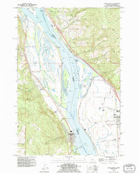 1990 Deer Island1995 Print · USGSThe Columbia River islands and Washington-Oregon borderlands are captured here in the 1990s. Genealogists and local historians can trace family-named sites like Maple Hill and McBride Creek or locate the old Cem near Woodland.
 - 1990 Map of Kalama, 1995 Print
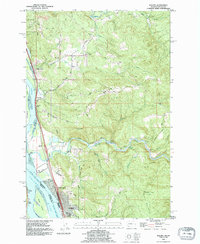 1990 Kalama1995 Print · USGSSettled along the busy river-and-rail corridor of the lower Columbia, this area in the early nineties shows a landscape balanced between industry and timbered uplands. Researchers can trace family sites at Rose Valley Cemetery, explore the riverside rail lines of the Burlington Northern, and locate old landmarks like the Salmon Hatchery and Carrolls Bluff.
End of results
Showing maps 1-2 of 2
Top cities near Kalama
- Longview historical maps
- Saint Helens historical maps
- Kelso historical maps
- Ridgefield historical maps
- Scappoose historical maps
- Woodland historical maps
See more
Frequently asked questions
- What are the different types of historical maps available for Kalama?
- What is the oldest map of Kalama?
- Where can I purchase historical maps of Kalama for my home or office?
- Where can I download high-res historical maps of Kalama?
- Are there historical topographic maps available for Kalama?
- Is there historical aerial imagery available for Kalama?
- Where are historical maps of Kalama sourced from?