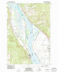
1990 Map of Deer Island
USGS Topo · Published 1995About this map
Columbia River islands and sloughs define the border between Oregon and Washington in this early 1990s record of the river's changing geometry. The sprawling landmass of Deer Island dominates the western channel, characterized by a complex network of interior water bodies including Cottonwood Lake, Swan Lake, and Thorn Lake. On the Oregon bank, the settlement of Columbia City and the hillside hamlet of Deer Island sit beneath the elevations of Maple Hill, while Woodland anchors the Washington side across the Martin Island Channel. The landscape reveals a heavy reliance on hydrological management, with an extensive system of dikes and levees protecting the low-lying basins. Local infrastructure is evidenced by the Old Pacific Highway and various industrial footprints, such as a Gravel Pit and Quarry, which suggest the ongoing extraction and transport economy of the Columbia basin.
Find a feature on this map
64 named features on this map. Tap any name to fly to it.
Don’t see what you’re looking for? This feature index may not catch every label — zoom into the map to look around manually.
Map Details
Editions of this 1990 Deer Island Map
This is the sole edition of this map. No revisions or reprints were ever made.
Other maps of this area

1921 · Kalama
USGS Topo · 1:62,500

1922 · St. Helens
USGS Topo · 1:62,500

1940 · La Center
USGS Topo · 1:62,500

1941 · St Helens
USGS Topo · 1:62,500

1943 · Pigeon Springs
USGS Topo · 1:62,500

1943 · St Helens
USGS Topo · 1:62,500

1948 · Vancouver
USGS Topo · 1:250,000

1950 · Vancouver
USGS Topo · 1:250,000

1950 · Vancouver
USGS Topo · 1:250,000

1953 · Hoquiam
USGS Topo · 1:250,000