1980s Maps of Toroda, Washington
Explore 2 historic maps of Toroda from the 1980s. These maps offer a rare glimpse into what life looked like during the 1980s — showing old roads, neighborhoods, homes, and landmarks that have changed or disappeared over time.
Whether you're researching your family's past, planning a metal detecting trip, or studying how Toroda's landscape evolved across the 1980s, these high-resolution maps are a powerful tool for exploring the history of this region.
- Focus on a specific era: All maps on this page are from the 1980s, giving you a focused view of this time period.
- See what’s changed: Compare century-old streets, trails, and buildings to today's modern landscape using overlays and satellite layers.
- Research with precision: Use these maps for genealogy, historical research, land use analysis, or educational projects.
- View, download, or print: Maps are fully viewable online in high resolution, and can be downloaded or printed for your own records.
Start exploring Toroda's history through authentic maps from the 1980s. This is your window into the past.
Toroda, WA maps
(2)- 1984 Map of Republic
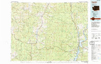 1984 Republic1984 Print · USGSThe Okanogan Highlands and Kettle River Range are shown in the mid-1980s, documenting a landscape shaped by mining and timber. Genealogists can trace old settlements like Bodie and Toroda, or locate historic workings such as the Knob Hill Mine and First Thought Mine.
 - 1988 Map of Toroda
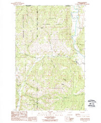 1988 Toroda1988 Print · USGSThe international border meets the mountain wilderness of Okanogan and Ferry counties in the late eighties. Researchers can trace remote homesteading history and river life through labels like the Eagle Cliff Cem, the Ferry river crossing, and the Ronald MacDonald Historical Site.
End of results
Showing maps 1-2 of 2
Frequently asked questions
- What are the different types of historical maps available for Toroda?
- What is the oldest map of Toroda?
- Where can I purchase historical maps of Toroda for my home or office?
- Where can I download high-res historical maps of Toroda?
- Are there historical topographic maps available for Toroda?
- Is there historical aerial imagery available for Toroda?
- Where are historical maps of Toroda sourced from?