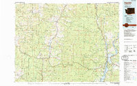
1984 Map of Republic
USGS Topo · Published 1984About this map
Republic serves as a focal point in this 1984 survey, situated near the western edge of the Kettle River Range. The map documents a rugged landscape defined by its mining history and timbered slopes within the Colville National Forest and Okanogan National Forest. Notable mineral claims like the Knob Hill Mine and Morning Glory Mine are charted near the townsite, reflecting the persistent economic importance of gold and silver extraction in this corner of Ferry County.
Find a feature on this map
149 named features on this map. Tap any name to fly to it.
Don’t see what you’re looking for? This feature index may not catch every label — zoom into the map to look around manually.
Map Details
Editions of this 1984 Republic Map
This is the sole edition of this map. No revisions or reprints were ever made.
Other maps of this area

1902 · Osoyoos
USGS Topo · 1:125,000

1904 · Osoyoos
USGS Topo · 1:125,000

1904 · Republic
USGS Topo · 1:125,000

1927 · Chewelah
USGS Topo · 1:125,000

1929 · Colville
USGS Topo · 1:125,000

1930 · Chewelah
USGS Topo · 1:125,000

1933 · Colville
USGS Topo · 1:125,000

1936 · Marcus
USGS Topo · 1:96,000

1942 · Marcus
USGS Topo · 1:125,000
1948 · Curlew
USGS Topo · 1:62,500