1900s (20th Century) Maps of Grand Coulee, Washington
Explore 9 historic maps of Grand Coulee from the 1900s (20th Century). These maps offer a rare glimpse into what life looked like during the 1900s — showing old roads, neighborhoods, homes, and landmarks that have changed or disappeared over time.
Whether you're researching your family's past, planning a metal detecting trip, or studying how Grand Coulee's landscape evolved across the 1900s, these high-resolution maps are a powerful tool for exploring the history of this region.
- Focus on a specific era: All maps on this page are from the 1900s, giving you a focused view of this time period.
- See what’s changed: Compare century-old streets, trails, and buildings to today's modern landscape using overlays and satellite layers.
- Research with precision: Use these maps for genealogy, historical research, land use analysis, or educational projects.
- View, download, or print: Maps are fully viewable online in high resolution, and can be downloaded or printed for your own records.
Start exploring Grand Coulee's history through authentic maps from the 1900s. This is your window into the past.
Grand Coulee, WA maps
(9)- 1948 Map of Grand Coulee Dam, 1955 Print
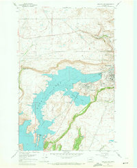
 1948 Grand Coulee Dam1955 Print · USGSThe Grand Coulee region underwent a massive transformation by the late 1940s as the dam transformed the river valley into a sprawling reservoir. Trace the growth of Coulee Dam and Grand Coulee, and locate rural landmarks like the Grand Coulee Grange and Bagdad Junction.6 unique versions available
 - 1950 Map of Grand Coulee Dam
 1950 Grand Coulee Dam1950 Print · USGSThe Grand Coulee region during the late 1940s reveals a landscape transformed by the new reservoir and the massive engineering of the dam. Researchers can trace local history through the Lafollette Cem, the community at Elmer City, and rural sites like the Grand Coulee Grange.2 unique versions available
 - 1953 Map of Ritzville, 1966 Print
 1953 Ritzville1966 Print · USGSEastern Washington was undergoing a massive agricultural and industrial transformation in the mid-fifties as irrigation from the Grand Coulee Dam reached the plateau. Researchers can trace the mid-century rail network of the Great Northern and locate vital local sites like Larson Air Force Base and Odessa.3 unique versions available
 - 1959 Map of Ritzville
 1959 Ritzville1959 Print · USGSEastern Washington in the late fifties reveals a landscape transformed by massive irrigation projects and postwar growth. Genealogists and historians can trace rail-line communities from Ritzville to Davenport and locate landmarks like Larson Air Force Base and Telford Station.
 - 1965 Map of Ritzville
 1965 Ritzville1965 Print · USGSCentral Washington during the mid-sixties shows a landscape shaped by massive irrigation projects and the Cold War. Genealogists and historians can trace rail-town life and military presence through Ephrata Air Base, the Telford Station, and local schools.
 - 1968 Map of Electric City, 1971 Print
 1968 Electric City1971 Print · USGSThe Coulee country comes into sharp focus during the late 1960s as these high-plateau towns grew alongside the massive Columbia Basin Project reservoirs. Trace the development of Electric City and Grand Coulee near the North Dam and landmarks like Steamboat Rock.
 - 1977 Map of Electric City, 1980 Print
 1977 Electric City1980 Print · USGSThe engineering landscape of the Columbia Basin comes into sharp focus in the late 1970s through this orthophotograph. Researchers can trace the development of Electric City and Grand Coulee or locate landmarks like Eagle Rock.
 - 1983 Map of Coulee Dam
 1983 Coulee Dam1983 Print · USGSThe high plateau and deep coulees of central Washington are captured here in the early eighties, centered on the massive Franklin D Roosevelt Lake and the towns of Coulee Dam and Grand Coulee. Researchers can trace the Burlington Northern rail corridor through old stops at Govan and Mondovi or locate the historic Fort Spokane.2 unique versions available
 - 1989 Map of Grand Coulee Dam
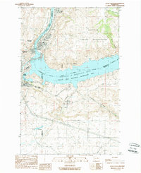 1989 Grand Coulee Dam1989 Print · USGSIn the late 1980s, the Columbia River landscape was defined by the massive scale of the Grand Coulee Dam and its surrounding government settlements. Researchers can trace the layout of Elmer City and Grand Coulee alongside infrastructure like the Pumping Station and Colville Indian Reservation.
End of results
Showing maps 1-9 of 9
Top cities near Grand Coulee
- Electric City historical maps
- Almira historical maps
- Elmer City historical maps
- Nespelem historical maps
Frequently asked questions
- What are the different types of historical maps available for Grand Coulee?
- What is the oldest map of Grand Coulee?
- Where can I purchase historical maps of Grand Coulee for my home or office?
- Where can I download high-res historical maps of Grand Coulee?
- Are there historical topographic maps available for Grand Coulee?
- Is there historical aerial imagery available for Grand Coulee?
- Where are historical maps of Grand Coulee sourced from?