1900s (20th Century) Maps of Moses Lake, Washington
Explore 13 historic maps of Moses Lake from the 1900s (20th Century). These maps offer a rare glimpse into what life looked like during the 1900s — showing old roads, neighborhoods, homes, and landmarks that have changed or disappeared over time.
Whether you're researching your family's past, planning a metal detecting trip, or studying how Moses Lake's landscape evolved across the 1900s, these high-resolution maps are a powerful tool for exploring the history of this region.
- Focus on a specific era: All maps on this page are from the 1900s, giving you a focused view of this time period.
- See what’s changed: Compare century-old streets, trails, and buildings to today's modern landscape using overlays and satellite layers.
- Research with precision: Use these maps for genealogy, historical research, land use analysis, or educational projects.
- View, download, or print: Maps are fully viewable online in high resolution, and can be downloaded or printed for your own records.
Start exploring Moses Lake's history through authentic maps from the 1900s. This is your window into the past.
Moses Lake, WA maps
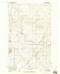
(13)- 1912 Map of Moses Lake
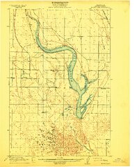 1912 Moses Lake1912 Print · USGSGrant County is captured in the early twentieth century before the major irrigation projects reshaped the desert. Genealogists can locate family holdings near Mae or trace the early paths to Hiawatha School and the unique geography of The Potholes.6 unique versions available
 - 1923 Map of Wheeler, 1952 Print
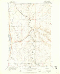
 1923 Wheeler1952 Print · USGSThe rural landscape of central Washington comes alive in the early 1920s as a major crossroads for competing rail lines. Genealogists and historians can trace numerous remote country schoolhouses like Keller School and Plain View School alongside rail stops at Ruff and Wheeler.
 - 1925 Map of Wheeler
 1925 Wheeler1925 Print · USGSThe Grant County prairie in the mid-twenties shows a landscape dominated by the high-desert rail economy and rural education. Researchers can trace the legacy of early homesteaders through local landmarks like Wheeler School, Bassett Junction, and Nagel.
 - 1953 Map of Ritzville, 1966 Print
 1953 Ritzville1966 Print · USGSEastern Washington was undergoing a massive agricultural and industrial transformation in the mid-fifties as irrigation from the Grand Coulee Dam reached the plateau. Researchers can trace the mid-century rail network of the Great Northern and locate vital local sites like Larson Air Force Base and Odessa.3 unique versions available
 - 1956 Map of Wheeler
 1956 Wheeler1956 Print · USGSCentral Grant County is captured in the mid-fifties as the railroad and new irrigation canals transformed the desert. Trace the industrial footprint of the Sugar Beet Refinery or locate the old siding at Banks and the Cemetery near Wheeler.3 unique versions available
 - 1956 Map of Moses Lake South, 1957 Print
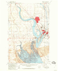
 1956 Moses Lake South1957 Print · USGSGrant County is shown here in the mid-1950s as the landscape transformed through major irrigation and reservoir projects. Researchers can trace the early layout of Westlake, the grounds of Moses Lake State Park, and the historic path of the Chicago Milwaukee St Paul and Pacific railroad.3 unique versions available
 - 1956 Map of Moses Lake North, 1957 Print
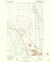 1956 Moses Lake North1957 Print · USGSMoses Lake entered a period of rapid mid-century expansion driven by the massive Larson Air Force Base and a complex new irrigation network. Researchers can trace the early residential street grids, school locations like Knolls Vista Sch, and the busy junction of the Northern Pacific railroad.4 unique versions available
 - 1956 Map of Sieler, 1958 Print
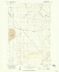 1956 Sieler1958 Print · USGSGrant County is captured in the mid-1950s as irrigation and the railroad transformed the high desert into an agricultural hub. Trace the vanished industrial landscape of the Sugar Beet Refinery and the small rail stops of Sieler and McDonald.3 unique versions available
 - 1956 Map of Wheeler, 1960 Print
 1956 Wheeler1960 Print · USGSIn the mid-1950s, the Columbia Basin landscape was being reshaped by large-scale irrigation and rail transit. Trace the growth of the region through the Sugar Refinery at Wheeler and the busy rail hub at Bassett Junction.2 unique versions available
 - 1956 Map of Moses Lake, 1960 Print
 1956 Moses Lake1960 Print · USGSMoses Lake and the surrounding Grant County desert are seen here during the mid-fifties expansion of the Columbia Basin Project. Genealogists and historians can locate the sprawling Larson Air Force Base, old school sites like Lakeview Sch, and the rural community of Mae.5 unique versions available
 - 1959 Map of Ritzville
 1959 Ritzville1959 Print · USGSEastern Washington in the late fifties reveals a landscape transformed by massive irrigation projects and postwar growth. Genealogists and historians can trace rail-line communities from Ritzville to Davenport and locate landmarks like Larson Air Force Base and Telford Station.
 - 1965 Map of Ritzville
 1965 Ritzville1965 Print · USGSCentral Washington during the mid-sixties shows a landscape shaped by massive irrigation projects and the Cold War. Genealogists and historians can trace rail-town life and military presence through Ephrata Air Base, the Telford Station, and local schools.
 - 1982 Map of Moses Lake, 1983 Print
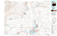 1982 Moses Lake1983 Print · USGSThe Columbia Basin during the early eighties shows a landscape transformed by large-scale irrigation and military aviation. Researchers can trace the development of Larson Air Force Base or locate vanished rail stops along the Burlington Northern near Ephrata and Quincy.2 unique versions available
End of results
Showing maps 1-13 of 13
Top cities near Moses Lake
Top neighborhoods of Moses Lake
Frequently asked questions
- What are the different types of historical maps available for Moses Lake?
- What is the oldest map of Moses Lake?
- Where can I purchase historical maps of Moses Lake for my home or office?
- Where can I download high-res historical maps of Moses Lake?
- Are there historical topographic maps available for Moses Lake?
- Is there historical aerial imagery available for Moses Lake?
- Where are historical maps of Moses Lake sourced from?