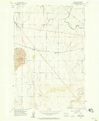
1956 Map of Sieler
USGS Topo · Published 1958About this map
The Chicago Milwaukee St Paul and Pacific railroad cuts a diagonal path through this Grant County landscape, connecting the small rail stops of Sieler and McDonald. The map reveals an intensive water management system critical to local agriculture, dominated by the East Low Canal and a network of siphons and pipelines that draw from Lind Coulee. This infrastructure supported industrial operations like the Sugar Beet Refinery in the northern reaches, while the Base Line Road provided a primary east-west corridor for the region's early automotive era. To the west, the shifting topography of the Sand Dunes stands in stark contrast to the surveyed irrigation plots. Local social landmarks include a Drive-in Theater and a lone Cemetery, providing specific points of interest for genealogists and local historians tracing the mid-century development of the Columbia Basin.
Find a feature on this map
18 named features on this map. Tap any name to fly to it.
Don’t see what you’re looking for? This feature index may not catch every label — zoom into the map to look around manually.
Map Details
Editions of this 1956 Sieler Map
Other maps of this area

1912 · Moses Lake
USGS Topo · 1:62,500

1923 · Corfu
USGS Topo · 1:62,500

1923 · Wheeler
USGS Topo · 1:62,500

1924 · Othello
USGS Topo · 1:62,500

1925 · Wheeler
USGS Topo · 1:62,500

1951 · Corfu
USGS Topo · 1:62,500

1953 · Walla Walla
USGS Topo · 1:250,000

1953 · Ritzville
USGS Topo · 1:250,000

1954 · Warden
USGS Topo · 1:24,000

1954 · Soda Lake
USGS Topo · 1:24,000