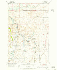
1954 Map of Soda Lake
USGS Topo · Published 1956About this map
Columbia National Wildlife Refuge dominates the southern landscape of this mid-1950s survey, illustrating a complex watery environment managed for conservation and irrigation. The terrain is characterized by the distinctive Potholes topography, where numerous small bodies of water like Sage Lakes, Widgeon Lake, and Crescent Lake are gathered. This network of lakes and reservoirs is interconnected by significant infrastructure, including the East Canal and the massive Potholes Levee, which control water flow across the Grant and Adams county line.
Find a feature on this map
30 named features on this map. Tap any name to fly to it.
Don’t see what you’re looking for? This feature index may not catch every label — zoom into the map to look around manually.
Map Details
Editions of this 1954 Soda Lake Map
2 editions found

Other maps of this area
1912 · Moses Lake
USGS Topo · 1:62,500

1923 · Corfu
USGS Topo · 1:62,500

1923 · Wheeler
USGS Topo · 1:62,500

1924 · Othello
USGS Topo · 1:62,500

1925 · Wheeler
USGS Topo · 1:62,500

1951 · Corfu
USGS Topo · 1:62,500

1953 · Walla Walla
USGS Topo · 1:250,000

1953 · Ritzville
USGS Topo · 1:250,000
1954 · Bruce
USGS Topo · 1:24,000
1954 · Warden
USGS Topo · 1:24,000