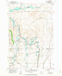
1954 Map of Soda Lake
USGS Topo · Published 1963About this map
Columbia National Wildlife Refuge dominates the landscape of the mid-1950s in this portion of central Washington, where complex water management systems redefine the arid terrain. The map documents the extensive infrastructure of the Columbia Basin Project, including the Potholes Levee, the Potholes Canal, and the Lind Reservoir. These man-made features altered the natural drainage of Crab Creek, creating a chain of water bodies such as Soda Lake, Canal Lake, and Crescent Lake. In the southeast corner, the Chicago Milwaukee St Paul and Pacific railroad tracks pass through the small settlement of Novara. The topography is characterized by the coulees and rocky depressions typical of the region, with Jackass Mtn rising above the surrounding lakes and numerous scattered windmills indicating the reliance on groundwater for local ranching and agriculture.
Find a feature on this map
36 named features on this map. Tap any name to fly to it.
Don’t see what you’re looking for? This feature index may not catch every label — zoom into the map to look around manually.
Map Details
Editions of this 1954 Soda Lake Map
2 editions found

Other maps of this area

1912 · Moses Lake
USGS Topo · 1:62,500

1923 · Corfu
USGS Topo · 1:62,500

1923 · Wheeler
USGS Topo · 1:62,500

1924 · Othello
USGS Topo · 1:62,500

1925 · Wheeler
USGS Topo · 1:62,500

1951 · Corfu
USGS Topo · 1:62,500

1953 · Walla Walla
USGS Topo · 1:250,000

1953 · Ritzville
USGS Topo · 1:250,000

1954 · Bruce
USGS Topo · 1:24,000

1954 · Warden
USGS Topo · 1:24,000