1980s Maps of Elma, Washington
Explore 3 historic maps of Elma from the 1980s. These maps offer a rare glimpse into what life looked like during the 1980s — showing old roads, neighborhoods, homes, and landmarks that have changed or disappeared over time.
Whether you're researching your family's past, planning a metal detecting trip, or studying how Elma's landscape evolved across the 1980s, these high-resolution maps are a powerful tool for exploring the history of this region.
- Focus on a specific era: All maps on this page are from the 1980s, giving you a focused view of this time period.
- See what’s changed: Compare century-old streets, trails, and buildings to today's modern landscape using overlays and satellite layers.
- Research with precision: Use these maps for genealogy, historical research, land use analysis, or educational projects.
- View, download, or print: Maps are fully viewable online in high resolution, and can be downloaded or printed for your own records.
Start exploring Elma's history through authentic maps from the 1980s. This is your window into the past.
Elma, WA maps
(3)- 1981 Map of Elma
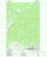 1981 Elma1981 Print · USGSGrays Harbor County at the start of the eighties shows a landscape shaped by the Satsop River and the Burlington Northern line. Researchers can pinpoint property near Hunters Prairie, trace the Old RR Grade, or locate family sites by the Cem in Elma.
 - 1986 Map of South Elma
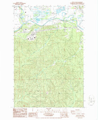 1986 South Elma1986 Print · USGSGrays Harbor County’s river valleys and timbered highlands are captured in the mid-1980s, showcasing the agricultural and industrial landscape south of the Chehalis. Researchers can trace historic locations like Weikswood or find local landmarks such as Saginaw, Fuller, and the Bay Scout Camp.2 unique versions available
 - 1988 Map of Shelton
 1988 Shelton1988 Print · USGSThe Olympic Peninsula's transition from high mountain wilderness to Puget Sound tideflats is captured here in the late eighties. Researchers can trace the path of the Logging Railroad or locate historical sites like Sanderson Field and the Skokomish Indian Reservation.
End of results
Showing maps 1-3 of 3
Top cities near Elma
Frequently asked questions
- What are the different types of historical maps available for Elma?
- What is the oldest map of Elma?
- Where can I purchase historical maps of Elma for my home or office?
- Where can I download high-res historical maps of Elma?
- Are there historical topographic maps available for Elma?
- Is there historical aerial imagery available for Elma?
- Where are historical maps of Elma sourced from?