1900s (20th Century) Maps of Neilton, Washington
Explore 7 historic maps of Neilton from the 1900s (20th Century). These maps offer a rare glimpse into what life looked like during the 1900s — showing old roads, neighborhoods, homes, and landmarks that have changed or disappeared over time.
Whether you're researching your family's past, planning a metal detecting trip, or studying how Neilton's landscape evolved across the 1900s, these high-resolution maps are a powerful tool for exploring the history of this region.
- Focus on a specific era: All maps on this page are from the 1900s, giving you a focused view of this time period.
- See what’s changed: Compare century-old streets, trails, and buildings to today's modern landscape using overlays and satellite layers.
- Research with precision: Use these maps for genealogy, historical research, land use analysis, or educational projects.
- View, download, or print: Maps are fully viewable online in high resolution, and can be downloaded or printed for your own records.
Start exploring Neilton's history through authentic maps from the 1900s. This is your window into the past.
Neilton, WA maps
(7)- 1921 Map of Quinault Lake
 1921 Quinault Lake1921 Print · USGSThe western Olympic Peninsula comes into focus in the early 1920s as forestry and local travel began to reshape the river valleys. Researchers can trace the path of the Olympic Highway through the Quinault Indian Reservation past landmarks like Chow Chow Prairie and Lone Mt.
 - 1955 Map of Quinault Lake, 1957 Print
 1955 Quinault Lake1957 Print · USGSThe Olympic Peninsula's dense timberlands and recreational corridors are captured here during the mid-fifties. Researchers can trace the industrial Logging RR network, the Quinault Lake School, and various forest camps like Falls Creek Forest Camp.3 unique versions available
 - 1958 Map of Seattle, 1966 Print
 1958 Seattle1966 Print · USGSThe Puget Sound region in the mid-fifties showcases a balance of urban growth and Olympic wilderness. Trace the industrial waterfronts of Tacoma, old naval facilities like Keyport Naval Res, and mountain peaks like Mount Constance.3 unique versions available
 - 1962 Map of Seattle
 1962 Seattle1962 Print · USGSThe Puget Sound region and Olympic Peninsula are shown at a peak of mid-century growth. Genealogists and historians can trace rail lines like the Pacific Coast RR or locate landmarks such as Fort Lawton and the Bothell Power Station.
 - 1988 Map of Shelton
 1988 Shelton1988 Print · USGSThe Olympic Peninsula's transition from high mountain wilderness to Puget Sound tideflats is captured here in the late eighties. Researchers can trace the path of the Logging Railroad or locate historical sites like Sanderson Field and the Skokomish Indian Reservation.
 - 1990 Map of Lake Quinault West
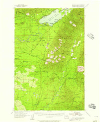
 1990 Lake Quinault West1990 Print · USGSThe Quinault River valley and Olympic foothills are captured here in the 1990s, showing the intersection of tribal and federal lands. Researchers can trace the Old Railroad Grade or locate family roots in Amanda Park and Neilton.
 - 1995 Map of Lake Quinault West, 1997 Print
 1995 Lake Quinault West1997 Print · USGSThe Lake Quinault region in the mid-1990s shows a landscape shaped by indigenous land rights and federal forest management. Genealogists and historians can trace the Old Railroad Grade past Chow Chow Prairie or locate family sites in Amanda Park and Neilton.
End of results
Showing maps 1-7 of 7
Top cities near Neilton
Frequently asked questions
- What are the different types of historical maps available for Neilton?
- What is the oldest map of Neilton?
- Where can I purchase historical maps of Neilton for my home or office?
- Where can I download high-res historical maps of Neilton?
- Are there historical topographic maps available for Neilton?
- Is there historical aerial imagery available for Neilton?
- Where are historical maps of Neilton sourced from?