1900s (20th Century) Maps of Ocean Shores, Washington
Explore 12 historic maps of Ocean Shores from the 1900s (20th Century). These maps offer a rare glimpse into what life looked like during the 1900s — showing old roads, neighborhoods, homes, and landmarks that have changed or disappeared over time.
Whether you're researching your family's past, planning a metal detecting trip, or studying how Ocean Shores's landscape evolved across the 1900s, these high-resolution maps are a powerful tool for exploring the history of this region.
- Focus on a specific era: All maps on this page are from the 1900s, giving you a focused view of this time period.
- See what’s changed: Compare century-old streets, trails, and buildings to today's modern landscape using overlays and satellite layers.
- Research with precision: Use these maps for genealogy, historical research, land use analysis, or educational projects.
- View, download, or print: Maps are fully viewable online in high resolution, and can be downloaded or printed for your own records.
Start exploring Ocean Shores's history through authentic maps from the 1900s. This is your window into the past.
Ocean Shores, WA maps
(12)- 1938 Map of Moclips, 1961 Print
 1938 Moclips1961 Print · USGSCoastal Grays Harbor County comes alive in this pre-war survey of the Washington shoreline and its timber-driven interior. Genealogists and researchers can trace the rail spurs of the Northern Pacific and locate historic mills and settlements like Aloha, Carlisle, and Stearnsville.2 unique versions available
 - 1941 Map of Moclips
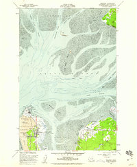
 1941 Moclips1941 Print · USGSThe Grays Harbor coastline was a bustling corridor of timber and milling just before the war. Researchers can trace the extensive Polson Logging Company rail lines, the Carlisle School, and industrial sites like the Stearns Shingle Mill.
 - 1941 Map of Grayland
 1941 Grayland1941 Print · USGSGrays Harbor and the Washington coast are captured here just before the mobilization of the early 1940s. Genealogists and historians can trace the foundations of Westport, locate the Western Logging Co Camp, and find maritime landmarks like the Grays Harbor L H.
 - 1943 Map of Copalis Beach
 1943 Copalis Beach1943 Print · USGSThe Washington coast in the 1940s is detailed here from the Olympic Peninsula to the Columbia River. Trace old beach settlements like Moclips and Copalis Beach alongside landmarks like the Willapa Bay Lighthouse.
 - 1951 Map of Copalis Beach
 1951 Copalis Beach1951 Print · USGSThe Olympic Peninsula's rugged coast and tribal lands are meticulously detailed in the early 1950s. Genealogists and historians can trace the foundations of coastal communities from Taholah to La Push or locate early markers like the James Island Lighthouse.
 - 1955 Map of Point Brown, 1959 Print
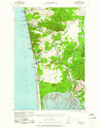
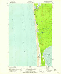
 1955 Point Brown1959 Print · USGSThe mouth of Grays Harbor is documented here in the mid-1950s, showing the early coastal development of the peninsula. Researchers can trace the layout of small outposts like Jetty Camp and Brown or the maritime infrastructure of the North Jetty and Coast Guard Reservation.6 unique versions available
 - 1955 Map of Copalis Beach, 1959 Print
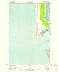
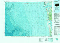
 1955 Copalis Beach1959 Print · USGSThe Grays Harbor coastline in the mid-1950s features a series of growing beachside communities nestled behind protective dunes. You can trace early coastal development from Copalis Beach down to Oyhut, identifying old structures, the Cem near Lang Lake, and the local Cranberry Bog.5 unique versions available
 - 1956 Map of Westport, 1959 Print
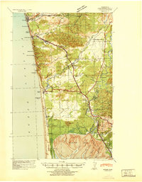
 1956 Westport1959 Print · USGSGrays Harbor at the mid-point of the twentieth century shows a landscape defined by maritime navigation and coastal industry. Trace the Old Railroad Grade past Ocosta or locate the Lighthouse and Coast Guard Reservation at Pt Chehalis.5 unique versions available
 - 1957 Map of Copalis Beach, 1968 Print
 1957 Copalis Beach1968 Print · USGSThe Washington coast during the late fifties reveals a landscape of tribal reservations and timber towns linked by the Northern Pacific RR. Trace family history and land patterns near Forks Cemetery, the shingle mill, or coastal landings like Taholah and Oysterville.2 unique versions available
 - 1963 Map of Copalis Beach
 1963 Copalis Beach1963 Print · USGSThe Washington coast in the early sixties reveals a landscape of massive timber reserves, indigenous lands, and quiet seaside villages. Genealogists and historians can trace the foundations of coastal life through sites like Lone Fir Cemetery, the Dismantled RR, and the historic oyster beds of Oysterville.
 - 1980 Map of Copalis Beach, 1988 Print
 1980 Copalis Beach1988 Print · USGSThe Grays Harbor coast in the early eighties shows a landscape defined by the Quinault Indian Reservation and seaside rail history. Researchers can trace the Burlington Northern route through Moclips, Aloha, and Copalis Crossing.
 - 1989 Map of Westport
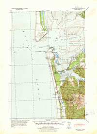
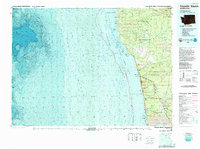
 1989 Westport1989 Print · USGSThe Washington coast and the mouth of Grays Harbor are captured in the late eighties, documenting the maritime infrastructure and coastal settlements of the era. Researchers can trace the development of Westport, Ocean Shores, and historic waterfronts like Oysterville or Bay City.
End of results
Showing maps 1-12 of 12
Top cities near Ocean Shores
Frequently asked questions
- What are the different types of historical maps available for Ocean Shores?
- What is the oldest map of Ocean Shores?
- Where can I purchase historical maps of Ocean Shores for my home or office?
- Where can I download high-res historical maps of Ocean Shores?
- Are there historical topographic maps available for Ocean Shores?
- Is there historical aerial imagery available for Ocean Shores?
- Where are historical maps of Ocean Shores sourced from?