1980s Maps of Ocean Shores, Washington
Explore 2 historic maps of Ocean Shores from the 1980s. These maps offer a rare glimpse into what life looked like during the 1980s — showing old roads, neighborhoods, homes, and landmarks that have changed or disappeared over time.
Whether you're researching your family's past, planning a metal detecting trip, or studying how Ocean Shores's landscape evolved across the 1980s, these high-resolution maps are a powerful tool for exploring the history of this region.
- Focus on a specific era: All maps on this page are from the 1980s, giving you a focused view of this time period.
- See what’s changed: Compare century-old streets, trails, and buildings to today's modern landscape using overlays and satellite layers.
- Research with precision: Use these maps for genealogy, historical research, land use analysis, or educational projects.
- View, download, or print: Maps are fully viewable online in high resolution, and can be downloaded or printed for your own records.
Start exploring Ocean Shores's history through authentic maps from the 1980s. This is your window into the past.
Ocean Shores, WA maps
(2)- 1980 Map of Copalis Beach, 1988 Print
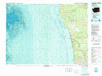 1980 Copalis Beach1988 Print · USGSThe Grays Harbor coast in the early eighties shows a landscape defined by the Quinault Indian Reservation and seaside rail history. Researchers can trace the Burlington Northern route through Moclips, Aloha, and Copalis Crossing.
 - 1989 Map of Westport
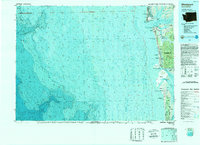 1989 Westport1989 Print · USGSThe Washington coast and the mouth of Grays Harbor are captured in the late eighties, documenting the maritime infrastructure and coastal settlements of the era. Researchers can trace the development of Westport, Ocean Shores, and historic waterfronts like Oysterville or Bay City.
End of results
Showing maps 1-2 of 2
Top cities near Ocean Shores
Frequently asked questions
- What are the different types of historical maps available for Ocean Shores?
- What is the oldest map of Ocean Shores?
- Where can I purchase historical maps of Ocean Shores for my home or office?
- Where can I download high-res historical maps of Ocean Shores?
- Are there historical topographic maps available for Ocean Shores?
- Is there historical aerial imagery available for Ocean Shores?
- Where are historical maps of Ocean Shores sourced from?