
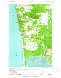
1938 Map of Moclips
USGS Topo · Published 1961About this map
The Aloha Logging Company Mill and the Northern Pacific railroad define the industrial character of this coastal timber landscape in the late 1930s. Coastal settlements like Moclips, Pacific Beach, and Copalis Beach dot the shoreline, connected by State Route 9C and rugged logging roads. The map illustrates a transitional economy where timber extraction, represented by the Aloha Logging Company and lines stretching toward Stearnsville, meets the growing recreational appeal of the Pacific front at Ocean City and Roosevelt Beach. To the north, the Quinault Indian Reservation boundary follows the Quinault River, while the inland area is marked by the winding courses of the Humptulips River and Copalis River. From the tidelands of North Bay to the high ground of Saddle Hill, the map documents the infrastructure of a working forest during the final years before the Second World War.
Find a feature on this map
54 named features on this map. Tap any name to fly to it.
Don’t see what you’re looking for? This feature index may not catch every label — zoom into the map to look around manually.
Map Details
Editions of this 1938 Moclips Map
2 editions found
Other maps of this area

1921 · Quinault Lake
USGS Topo · 1:62,500

1941 · Moclips
USGS Topo · 1:62,500

1941 · Grayland
USGS Topo · 1:62,500

1943 · Humptulips
USGS Topo · 1:62,500

1943 · Copalis Beach
USGS Topo · 1:250,000

1951 · Copalis Beach
USGS Topo · 1:250,000

1953 · Hoquiam
USGS Topo · 1:250,000

1955 · Taholah
USGS Topo · 1:62,500

1955 · Macafee Hill
USGS Topo · 1:62,500

1955 · Humptulips
USGS Topo · 1:62,500