1950s Maps of Port Townsend, Washington
Explore 5 historic maps of Port Townsend from the 1950s. These maps offer a rare glimpse into what life looked like during the 1950s — showing old roads, neighborhoods, homes, and landmarks that have changed or disappeared over time.
Whether you're researching your family's past, planning a metal detecting trip, or studying how Port Townsend's landscape evolved across the 1950s, these high-resolution maps are a powerful tool for exploring the history of this region.
- Focus on a specific era: All maps on this page are from the 1950s, giving you a focused view of this time period.
- See what’s changed: Compare century-old streets, trails, and buildings to today's modern landscape using overlays and satellite layers.
- Research with precision: Use these maps for genealogy, historical research, land use analysis, or educational projects.
- View, download, or print: Maps are fully viewable online in high resolution, and can be downloaded or printed for your own records.
Start exploring Port Townsend's history through authentic maps from the 1950s. This is your window into the past.
Port Townsend, WA maps
(5)- 1953 Map of Coupeville, 1955 Print
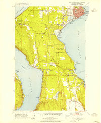
 1953 Coupeville1955 Print · USGSWhidbey Island in the early fifties shows a balance of historic prairie farming and vital Cold War military operations. Researchers can trace the legacy of Coupeville and Ebeys Landing or locate maritime landmarks like the Keystone Ferry Landing and the Lighthouse (Aband'd).3 unique versions available
 - 1953 Map of Nordland, 1955 Print
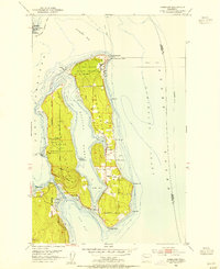 1953 Nordland1955 Print · USGSJefferson County’s coastal islands and military outposts are documented here in the early fifties, showing the area's transition into a strategic naval hub. Genealogists and researchers can locate Nordland, trace family plots at Sound View Cemetery, and explore the grounds of Fort Flagler Military Reservation.4 unique versions available
 - 1953 Map of Port Townsend North, 1955 Print
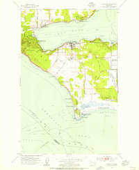
 1953 Port Townsend North1955 Print · USGSThe entrance to Puget Sound in the early fifties shows a landscape shaped by coastal defense and maritime commerce. Trace the grounds of Fort Worden Military Res, the lighthouse at Point Wilson, and the ferry lanes crossing the Strait of Juan de Fuca.3 unique versions available
 - 1953 Map of Port Townsend South, 1955 Print
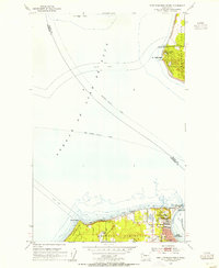
 1953 Port Townsend South1955 Print · USGSThe Quimper Peninsula in the mid-1950s is a landscape of coastal industry and rural valley life. Genealogists and historians can trace the rail corridor of the Chicago Milwaukee St Paul and Pacific or locate residents near Irondale, Hadlock, and Laurel Grove Cem.4 unique versions available
 - 1957 Map of Victoria, 1960 Print
 1957 Victoria1960 Print · USGSThe San Juan Islands and the North Cascades coastline are shown in detail during the late fifties, a period of significant military and industrial presence. Researchers can trace historic rail lines like the Great Northern or locate sites such as the Whidbey Island Naval Air Sta and Friday Harbor.4 unique versions available
End of results
Showing maps 1-5 of 5
Top cities near Port Townsend
- Oak Harbor historical maps
- Port Hadlock historical maps
- Port Ludlow historical maps
- Coupeville historical maps
- Blyn historical maps
Top neighborhoods of Port Townsend
- Rosewind historical maps
- Towne Point historical maps
- Umatilla Hill historical maps
- Business Park historical maps
- Dundee Hill historical maps
- Hamilton Heights historical maps
See more
Frequently asked questions
- What are the different types of historical maps available for Port Townsend?
- What is the oldest map of Port Townsend?
- Where can I purchase historical maps of Port Townsend for my home or office?
- Where can I download high-res historical maps of Port Townsend?
- Are there historical topographic maps available for Port Townsend?
- Is there historical aerial imagery available for Port Townsend?
- Where are historical maps of Port Townsend sourced from?