1900s (20th Century) Maps of Seal Rock, Washington
Explore 8 historic maps of Seal Rock from the 1900s (20th Century). These maps offer a rare glimpse into what life looked like during the 1900s — showing old roads, neighborhoods, homes, and landmarks that have changed or disappeared over time.
Whether you're researching your family's past, planning a metal detecting trip, or studying how Seal Rock's landscape evolved across the 1900s, these high-resolution maps are a powerful tool for exploring the history of this region.
- Focus on a specific era: All maps on this page are from the 1900s, giving you a focused view of this time period.
- See what’s changed: Compare century-old streets, trails, and buildings to today's modern landscape using overlays and satellite layers.
- Research with precision: Use these maps for genealogy, historical research, land use analysis, or educational projects.
- View, download, or print: Maps are fully viewable online in high resolution, and can be downloaded or printed for your own records.
Start exploring Seal Rock's history through authentic maps from the 1900s. This is your window into the past.
Seal Rock, WA maps
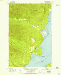
(8)- 1936 Map of Point Misery, 1958 Print
 1936 Point Misery1958 Print · USGSCommunities along the Hood Canal thrived on timber and maritime trade in the mid-1930s. Genealogists and historians can trace local landmarks like Seabeck, the Lewis Lumber Co, and the Brinnon Seabeck Ferry route.3 unique versions available
 - 1940 Map of Point Misery
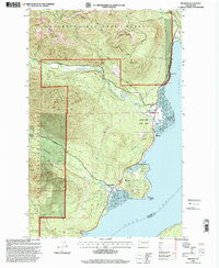
 1940 Point Misery1940 Print · USGSCoastal life along the Hood Canal and Dabob Bay is caught in detail just before the mid-century, from timber operations to maritime crossings. Genealogists and historians can trace the Brinnon Seabeck Ferry, identify the Barney White Ranch, and locate the Seabeck Sch.
 - 1953 Map of Brinnon, 1955 Print
 1953 Brinnon1955 Print · USGSBrinnon and the Olympic Peninsula coastline are captured here in the early fifties as the region's timber and maritime identity thrived. Researchers can trace historic forest service outposts like Interrorem Guard Station, the original Brinnon School, and the winding course of the Duckabush River.5 unique versions available
 - 1958 Map of Seattle, 1966 Print
 1958 Seattle1966 Print · USGSThe Puget Sound region in the mid-fifties showcases a balance of urban growth and Olympic wilderness. Trace the industrial waterfronts of Tacoma, old naval facilities like Keyport Naval Res, and mountain peaks like Mount Constance.3 unique versions available
 - 1962 Map of Seattle
 1962 Seattle1962 Print · USGSThe Puget Sound region and Olympic Peninsula are shown at a peak of mid-century growth. Genealogists and historians can trace rail lines like the Pacific Coast RR or locate landmarks such as Fort Lawton and the Bothell Power Station.
 - 1975 Map of Seattle, 1977 Print
 1975 Seattle1977 Print · USGSThe Puget Sound region in the mid-seventies shows a landscape of rapid suburban growth and vital maritime industry. Researchers can trace the development of Eastside hubs like Bellevue or examine the rail and naval infrastructure of Bremerton and Paine Field.
 - 1992 Map of Seattle, 1993 Print
 1992 Seattle1993 Print · USGSThe Seattle metropolitan area and Puget Sound are shown here in the early nineties during a period of rapid suburban and technological growth. Researchers can trace the development of Mercer Island, locate the Bangor Naval Submarine Base, and study the industrial layout of Boeing Field.2 unique versions available
 - 1999 Map of Brinnon, 2001 Print
 1999 Brinnon2001 Print · USGSThe western shores of Hood Canal come into sharp focus in the late nineties, where the mountains meet the sea. Local historians can trace the development of Brinnon and Brinnon Flats alongside the Dosewallips River and the rural Brinnon School.
End of results
Showing maps 1-8 of 8
Top cities near Seal Rock
- Bremerton historical maps
- Silverdale historical maps
- Port Orchard historical maps
- Poulsbo historical maps
- Port Ludlow historical maps
- Erlands Point-Kitsap Lake historical maps
See more
Frequently asked questions
- What are the different types of historical maps available for Seal Rock?
- What is the oldest map of Seal Rock?
- Where can I purchase historical maps of Seal Rock for my home or office?
- Where can I download high-res historical maps of Seal Rock?
- Are there historical topographic maps available for Seal Rock?
- Is there historical aerial imagery available for Seal Rock?
- Where are historical maps of Seal Rock sourced from?