1990s Maps of Enumclaw, Washington
Explore 5 historic maps of Enumclaw from the 1990s. These maps offer a rare glimpse into what life looked like during the 1990s — showing old roads, neighborhoods, homes, and landmarks that have changed or disappeared over time.
Whether you're researching your family's past, planning a metal detecting trip, or studying how Enumclaw's landscape evolved across the 1990s, these high-resolution maps are a powerful tool for exploring the history of this region.
- Focus on a specific era: All maps on this page are from the 1990s, giving you a focused view of this time period.
- See what’s changed: Compare century-old streets, trails, and buildings to today's modern landscape using overlays and satellite layers.
- Research with precision: Use these maps for genealogy, historical research, land use analysis, or educational projects.
- View, download, or print: Maps are fully viewable online in high resolution, and can be downloaded or printed for your own records.
Start exploring Enumclaw's history through authentic maps from the 1990s. This is your window into the past.
Enumclaw, WA maps
(5)- 1991 Map of Tacoma
 1991 Tacoma1991 Print · USGSThe South Sound and Tacoma waterfront appear here in the early nineties, showing a landscape defined by deep-water inlets and massive federal installations. Researchers can trace the development of Lakewood Center or locate the historic rail lines of the Burlington Northern Railroad and Union Pacific Railroad.
 - 1993 Map of Enumclaw
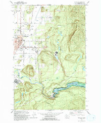 1993 Enumclaw1993 Print · USGSThe foothills of the Cascades near Enumclaw and Buckley are shown in the early nineties, centered on the White River corridor. Genealogists and historians can locate family landmarks like Pinnacle Peak, schools such as Byron Kibler Sch, and the massive Mud Mountain Dam infrastructure.
 - 1993 Map of Buckley
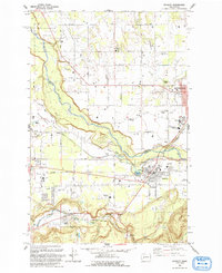 1993 Buckley1993 Print · USGSThe White River valley and the high prairies of Pierce and King counties are captured here in the early nineties. Researchers can trace the layout of Enumclaw and Buckley, locate the Krain Cemetery, and follow the Old RR Grade south toward Burnett.
 - 1997 Map of Enumclaw, 2003 Print
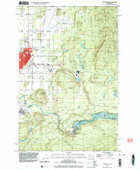 1997 Enumclaw2003 Print · USGSEnumclaw and Buckley are shown during the late 1990s as the regional hub for the White River valley. Trace local history through the Rainier State School, the Old Grade Railroad, and engineered landmarks like the Mud Mountain Dam.
 - 1997 Map of Buckley, 2003 Print
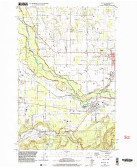 1997 Buckley2003 Print · USGSThe foothills of King and Pierce counties are captured here in the late nineties as timber and rail heritage meets modern growth. Researchers can trace historic landmarks like Finn Hall, the Old RR Grade, and the grounds of the Rainier State School.
End of results
Showing maps 1-5 of 5
Top cities near Enumclaw
- Kent historical maps
- Renton historical maps
- Auburn historical maps
- Maple Valley historical maps
- Bonney Lake historical maps
- Covington historical maps
See more
Top neighborhoods of Enumclaw
- Pinnacle Peak historical maps
- Rainier Trails historical maps
- Crystalaire historical maps
- Crystal Mountain Residences historical maps
- Watson Place Apartments historical maps
- Stonebrook historical maps
See more
Frequently asked questions
- What are the different types of historical maps available for Enumclaw?
- What is the oldest map of Enumclaw?
- Where can I purchase historical maps of Enumclaw for my home or office?
- Where can I download high-res historical maps of Enumclaw?
- Are there historical topographic maps available for Enumclaw?
- Is there historical aerial imagery available for Enumclaw?
- Where are historical maps of Enumclaw sourced from?