1980s Maps of White Horse Crossing, Kent
Explore 2 historic maps of White Horse Crossing from the 1980s. These maps offer a rare glimpse into what life looked like during the 1980s — showing old roads, neighborhoods, homes, and landmarks that have changed or disappeared over time.
Whether you're researching your family's past, planning a metal detecting trip, or studying how White Horse Crossing's landscape evolved across the 1980s, these high-resolution maps are a powerful tool for exploring the history of this region.
- Focus on a specific era: All maps on this page are from the 1980s, giving you a focused view of this time period.
- See what’s changed: Compare century-old streets, trails, and buildings to today's modern landscape using overlays and satellite layers.
- Research with precision: Use these maps for genealogy, historical research, land use analysis, or educational projects.
- View, download, or print: Maps are fully viewable online in high resolution, and can be downloaded or printed for your own records.
Start exploring White Horse Crossing's history through authentic maps from the 1980s. This is your window into the past.
White Horse Crossing, Kent maps
(2)- 1983 Map of Renton
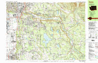 1983 Renton1983 Print · USGSRenton and the Cedar River valley are shown here in the early eighties as suburban growth began to surround the massive Lake Youngs Watershed. Researchers can trace local landmarks like Greenwood Cem, the Burlington Northern railroad, and established neighborhoods from Bryn Mawr to Maple Valley.
 - 1983 Map of Auburn
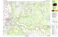 1983 Auburn1983 Print · USGSThe Green River valley and its surrounding plateaus come into focus in the early eighties as residential growth meets deep-rooted industrial corridors. Genealogists and historians can locate family landmarks like the Muckleshoot Indian Reservation, Black Diamond, and Auburn Adventist Academy.
End of results
Showing maps 1-2 of 2
Frequently asked questions
- What are the different types of historical maps available for White Horse Crossing?
- What is the oldest map of White Horse Crossing?
- Where can I purchase historical maps of White Horse Crossing for my home or office?
- Where can I download high-res historical maps of White Horse Crossing?
- Are there historical topographic maps available for White Horse Crossing?
- Is there historical aerial imagery available for White Horse Crossing?
- Where are historical maps of White Horse Crossing sourced from?