1950s Maps of Port Orchard, Washington
Explore 4 historic maps of Port Orchard from the 1950s. These maps offer a rare glimpse into what life looked like during the 1950s — showing old roads, neighborhoods, homes, and landmarks that have changed or disappeared over time.
Whether you're researching your family's past, planning a metal detecting trip, or studying how Port Orchard's landscape evolved across the 1950s, these high-resolution maps are a powerful tool for exploring the history of this region.
- Focus on a specific era: All maps on this page are from the 1950s, giving you a focused view of this time period.
- See what’s changed: Compare century-old streets, trails, and buildings to today's modern landscape using overlays and satellite layers.
- Research with precision: Use these maps for genealogy, historical research, land use analysis, or educational projects.
- View, download, or print: Maps are fully viewable online in high resolution, and can be downloaded or printed for your own records.
Start exploring Port Orchard's history through authentic maps from the 1950s. This is your window into the past.
Port Orchard, WA maps
(4)- 1953 Map of Burley, 1954 Print
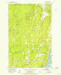 1953 Burley1954 Print · USGSThe Kitsap Peninsula is captured here in the early fifties, showing a rural landscape of timber and tide. Researchers can trace the development of early communities like Burley, Glenwood, and Bethel, or locate landmarks such as Bethel Ch and South Port Orchard Airport.6 unique versions available
 - 1953 Map of Bremerton West, 1955 Print
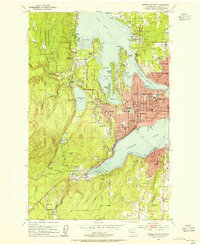 1953 Bremerton West1955 Print · USGSKitsap County during the early fifties reveals a landscape defined by the Puget Sound Naval Shipyard and its surrounding coastal communities. Genealogists can trace family homes near Kitsap Lake or locate ancestral plots at Ivy Green Cem and Forest Lawn Cem.5 unique versions available
 - 1953 Map of Bremerton East, 1955 Print
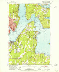 1953 Bremerton East1955 Print · USGSThe Kitsap Peninsula and Bainbridge Island shorelines appear in the early fifties, caught between their naval legacy and post-war growth. Researchers can trace family sites from Winslow to Harper or locate ancestors at the Port Blakely Cemetery and Veterans Home Cem.4 unique versions available
 - 1958 Map of Seattle, 1966 Print
 1958 Seattle1966 Print · USGSThe Puget Sound region in the mid-fifties showcases a balance of urban growth and Olympic wilderness. Trace the industrial waterfronts of Tacoma, old naval facilities like Keyport Naval Res, and mountain peaks like Mount Constance.3 unique versions available
End of results
Showing maps 1-4 of 4
Top cities near Port Orchard
- Seattle historical maps
- Tacoma historical maps
- Bremerton historical maps
- Bainbridge Island historical maps
- Silverdale historical maps
- Artondale historical maps
See more
Top neighborhoods of Port Orchard
Frequently asked questions
- What are the different types of historical maps available for Port Orchard?
- What is the oldest map of Port Orchard?
- Where can I purchase historical maps of Port Orchard for my home or office?
- Where can I download high-res historical maps of Port Orchard?
- Are there historical topographic maps available for Port Orchard?
- Is there historical aerial imagery available for Port Orchard?
- Where are historical maps of Port Orchard sourced from?