1980s Maps of Cle Elum, Washington
Explore 2 historic maps of Cle Elum from the 1980s. These maps offer a rare glimpse into what life looked like during the 1980s — showing old roads, neighborhoods, homes, and landmarks that have changed or disappeared over time.
Whether you're researching your family's past, planning a metal detecting trip, or studying how Cle Elum's landscape evolved across the 1980s, these high-resolution maps are a powerful tool for exploring the history of this region.
- Focus on a specific era: All maps on this page are from the 1980s, giving you a focused view of this time period.
- See what’s changed: Compare century-old streets, trails, and buildings to today's modern landscape using overlays and satellite layers.
- Research with precision: Use these maps for genealogy, historical research, land use analysis, or educational projects.
- View, download, or print: Maps are fully viewable online in high resolution, and can be downloaded or printed for your own records.
Start exploring Cle Elum's history through authentic maps from the 1980s. This is your window into the past.
Cle Elum, WA maps
(2)- 1984 Map of Cle Elum, 1985 Print
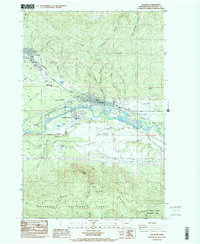 1984 Cle Elum1985 Print · USGSKittitas County coal and rail hubs come to life in the 1980s as the regional economy transitions. Genealogists and historians can trace the proximity of Roslyn to various workings like No 5 Mine and locate civic landmarks such as Cle Elum High Sch.2 unique versions available
 - 1989 Map of Ronald
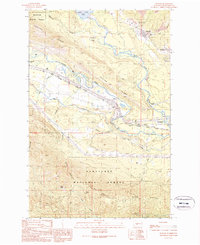 1989 Ronald1989 Print · USGSThe mining corridor between Ronald and Roslyn is captured here during the late eighties, showing the region's transition from an industrial hub to a recreational gateway. Genealogists and historians can locate the Roslyn Cascade Mine No 4, the local Cem, and the route of the John Wayne Pioneer State Park Trail (Pack).2 unique versions available
End of results
Showing maps 1-2 of 2
Top cities near Cle Elum
Frequently asked questions
- What are the different types of historical maps available for Cle Elum?
- What is the oldest map of Cle Elum?
- Where can I purchase historical maps of Cle Elum for my home or office?
- Where can I download high-res historical maps of Cle Elum?
- Are there historical topographic maps available for Cle Elum?
- Is there historical aerial imagery available for Cle Elum?
- Where are historical maps of Cle Elum sourced from?