1900s (20th Century) Maps of Cispus, Washington
Explore 8 historic maps of Cispus from the 1900s (20th Century). These maps offer a rare glimpse into what life looked like during the 1900s — showing old roads, neighborhoods, homes, and landmarks that have changed or disappeared over time.
Whether you're researching your family's past, planning a metal detecting trip, or studying how Cispus's landscape evolved across the 1900s, these high-resolution maps are a powerful tool for exploring the history of this region.
- Focus on a specific era: All maps on this page are from the 1900s, giving you a focused view of this time period.
- See what’s changed: Compare century-old streets, trails, and buildings to today's modern landscape using overlays and satellite layers.
- Research with precision: Use these maps for genealogy, historical research, land use analysis, or educational projects.
- View, download, or print: Maps are fully viewable online in high resolution, and can be downloaded or printed for your own records.
Start exploring Cispus's history through authentic maps from the 1900s. This is your window into the past.
Cispus, WA maps
(8)- 1919 Map of Mount St Helens
 1919 Mount St Helens1919 Print · USGSThe Cascades wilderness of Cowlitz and Skamania counties comes alive in this era of early forest management and mining. Trace the original profiles of Mt St Helens and Spirit Lake, and locate remote landmarks like Polar Star Mine or Basket Ferry.4 unique versions available
 - 1953 Map of Hoquiam
 1953 Hoquiam1953 Print · USGSSouthwest Washington in the early fifties shows a landscape shaped by timber, rail, and river commerce from the coast to the Cascades. Genealogists and historians can trace the development of timber towns like Ryderwood and the industrial hubs of Hoquiam and Kelso.2 unique versions available
 - 1957 Map of Hoquiam
 1957 Hoquiam1957 Print · USGSCoastal timber ports and inland rail hubs define Southwest Washington during the late fifties. Genealogists can trace early twentieth-century settlements like Bordeaux, Tono, and Cosmopolis alongside the expanding tracks of the Northern Pacific.
 - 1957 Map of Spirit Lake, 1959 Print
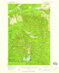 1957 Spirit Lake1959 Print · USGSThe Gifford Pinchot National Forest in the late fifties is captured here as a thriving hub of recreation and mining before the 1980 eruption altered the landscape. Researchers can trace historic lakeside developments like Harmony Falls Lodge or locate early industrial sites such as the Polar Star Mine and the Cowlitz Chehalis & Cascade Railroad.3 unique versions available
 - 1958 Map of Hoquiam, 1969 Print
 1958 Hoquiam1969 Print · USGSSouthwest Washington and the Columbia River estuary appear here in the mid-century, before major landscape shifts. Researchers can trace the rail lines of the Northern Pacific, locate the Fort Henness Site, or explore the Naselle Air Force Station.2 unique versions available
 - 1962 Map of Hoquiam
 1962 Hoquiam1962 Print · USGSSouthwest Washington in the late fifties is defined by the bustling timber ports of Hoquiam and the rail-linked commerce of the interior valleys. Genealogists and historians can trace the early footprints of settlements like Raymond and Pe Ell, or locate family sites at Grand Mound Cem and Odd Fellows Cem.
 - 1983 Map of Cowlitz Falls, 1984 Print
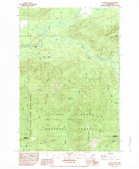 1983 Cowlitz Falls1984 Print · USGSThe Gifford Pinchot National Forest meets the Mount St. Helens National Volcanic Monument in the early eighties. Researchers can trace remote mountain access via Pack Trail and 4WD routes to sites like Kelly Ranch, Deep Lake, and Cowlitz Falls.2 unique versions available
 - 1994 Map of Cowlitz Falls, 1996 Print
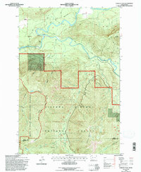 1994 Cowlitz Falls1996 Print · USGSThe Lewis and Skamania county line runs through this mid-nineties survey of the Cowlitz River basin. Researchers can trace the timber and water landscape from the Gaging Station and Landing Strip to landmarks like Quartz Creek Big Trees.
End of results
Showing maps 1-8 of 8
Top cities near Cispus
Frequently asked questions
- What are the different types of historical maps available for Cispus?
- What is the oldest map of Cispus?
- Where can I purchase historical maps of Cispus for my home or office?
- Where can I download high-res historical maps of Cispus?
- Are there historical topographic maps available for Cispus?
- Is there historical aerial imagery available for Cispus?
- Where are historical maps of Cispus sourced from?