1900s (20th Century) Maps of Oakland, Washington
Explore 6 historic maps of Oakland from the 1900s (20th Century). These maps offer a rare glimpse into what life looked like during the 1900s — showing old roads, neighborhoods, homes, and landmarks that have changed or disappeared over time.
Whether you're researching your family's past, planning a metal detecting trip, or studying how Oakland's landscape evolved across the 1900s, these high-resolution maps are a powerful tool for exploring the history of this region.
- Focus on a specific era: All maps on this page are from the 1900s, giving you a focused view of this time period.
- See what’s changed: Compare century-old streets, trails, and buildings to today's modern landscape using overlays and satellite layers.
- Research with precision: Use these maps for genealogy, historical research, land use analysis, or educational projects.
- View, download, or print: Maps are fully viewable online in high resolution, and can be downloaded or printed for your own records.
Start exploring Oakland's history through authentic maps from the 1900s. This is your window into the past.
Oakland, WA maps
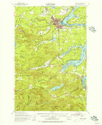
(6)- 1939 Map of Shelton
 1939 Shelton1939 Print · USGSSouth Puget Sound during the late thirties reveals a region defined by its timber-hauling railroads and intricate shorelines. Researchers can trace the legacy of early settlements and industry at Shelton, Kamilche, and transit points like Sawmill Sta or the Wilson Ranch.
 - 1953 Map of Shelton, 1956 Print
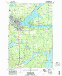
 1953 Shelton1956 Print · USGSThe Mason County waterfront and its timbered interior come alive in this mid-century survey of the inlets surrounding Shelton. Trace the legacy of rural education and military history at Bordeaux Sch, New Kamilche, and the Naval Auxiliary Air Station.2 unique versions available
 - 1958 Map of Seattle, 1966 Print
 1958 Seattle1966 Print · USGSThe Puget Sound region in the mid-fifties showcases a balance of urban growth and Olympic wilderness. Trace the industrial waterfronts of Tacoma, old naval facilities like Keyport Naval Res, and mountain peaks like Mount Constance.3 unique versions available
 - 1962 Map of Seattle
 1962 Seattle1962 Print · USGSThe Puget Sound region and Olympic Peninsula are shown at a peak of mid-century growth. Genealogists and historians can trace rail lines like the Pacific Coast RR or locate landmarks such as Fort Lawton and the Bothell Power Station.
 - 1981 Map of Shelton, 1982 Print
 1981 Shelton1982 Print · USGSThe Puget Sound shoreline near Shelton is documented here in the early eighties, showing the region's dense network of inlets and timber-driven infrastructure. Researchers can trace the Burlington Northern rail lines or locate landmarks like Shelton Mem Park (Cem) and the Drive-in Theater.2 unique versions available
 - 1988 Map of Shelton
 1988 Shelton1988 Print · USGSThe Olympic Peninsula's transition from high mountain wilderness to Puget Sound tideflats is captured here in the late eighties. Researchers can trace the path of the Logging Railroad or locate historical sites like Sanderson Field and the Skokomish Indian Reservation.
End of results
Showing maps 1-6 of 6
Top cities near Oakland
- Olympia historical maps
- Tumwater historical maps
- Shelton historical maps
- Kamilche historical maps
- McCleary historical maps
- Union historical maps
Frequently asked questions
- What are the different types of historical maps available for Oakland?
- What is the oldest map of Oakland?
- Where can I purchase historical maps of Oakland for my home or office?
- Where can I download high-res historical maps of Oakland?
- Are there historical topographic maps available for Oakland?
- Is there historical aerial imagery available for Oakland?
- Where are historical maps of Oakland sourced from?