1980s Maps of Paradise Hill, Washington
Explore 2 historic maps of Paradise Hill from the 1980s. These maps offer a rare glimpse into what life looked like during the 1980s — showing old roads, neighborhoods, homes, and landmarks that have changed or disappeared over time.
Whether you're researching your family's past, planning a metal detecting trip, or studying how Paradise Hill's landscape evolved across the 1980s, these high-resolution maps are a powerful tool for exploring the history of this region.
- Focus on a specific era: All maps on this page are from the 1980s, giving you a focused view of this time period.
- See what’s changed: Compare century-old streets, trails, and buildings to today's modern landscape using overlays and satellite layers.
- Research with precision: Use these maps for genealogy, historical research, land use analysis, or educational projects.
- View, download, or print: Maps are fully viewable online in high resolution, and can be downloaded or printed for your own records.
Start exploring Paradise Hill's history through authentic maps from the 1980s. This is your window into the past.
Paradise Hill, WA maps
(2)- 1983 Map of Omak
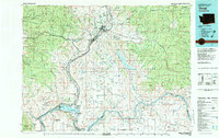 1983 Omak1983 Print · USGSIn the early 1980s, the Okanogan and Columbia river valleys served as a vital agricultural and timber hub. Researchers can trace family-named landmarks like Pearl Hill and Jackass Butte, alongside vanished mining history at the Red Shirt Mine.2 unique versions available
 - 1989 Map of Knowlton Knob
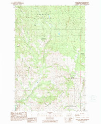 1989 Knowlton Knob1989 Print · USGSThe Okanogan backcountry in the late eighties reveals a high-elevation landscape of fire lookouts and mountain springs. Researchers can trace land use patterns through landmarks like the Knowlton Knob Lookout Tower, the Gambles Mill (Site), and a solitary Grave.2 unique versions available
End of results
Showing maps 1-2 of 2
Top cities near Paradise Hill
Frequently asked questions
- What are the different types of historical maps available for Paradise Hill?
- What is the oldest map of Paradise Hill?
- Where can I purchase historical maps of Paradise Hill for my home or office?
- Where can I download high-res historical maps of Paradise Hill?
- Are there historical topographic maps available for Paradise Hill?
- Is there historical aerial imagery available for Paradise Hill?
- Where are historical maps of Paradise Hill sourced from?